Tuesday, 29 May 2012

A scorching day on the South Glen Shiel Ridge


The old Road to the Isles, looking towards Cluanie
Last Friday provided a rare combination of fabulous weather and the opportunity for a spot of hillwalking. We decided on the South Glen Shiel Ridge, originally hoping to knock off the full seven Munros. However a later than intended start, a drive that took longer than my hopelessly optimistic prediction and a desire to return home at a reasonable hour to my extremely pregnant wife made a shorter day seem the more sensible option, so we contented ourselves with the eastern section of the ridge.

I left the van near the high point of the glen and cycled back to the Cluanie Inn where Paul and Tam the dog were sheltering in the shade of a tree. There are more direct routes to the ridge, but I was keen to follow the aesthetic line of the Old Road to the Isles, having been intrigued by its snaking path over the hills on previous visits to the glen. When Loch Loyne was dammed as part of a hydroelectric scheme part of the road and its impressive arch bridge disappeared beneath the waters. In times of drought the bridge emerges from its watery grave and the old road may be followed once again. 

View east along the ridge with the snowcapped peaks of the Cairngorms just visible in the centre
The weather was extremely hot, probably well into the 20s even on the tops. At first conditions were hazy, permitting only views of the adjacent peaks  but they cleared progressively as the day wore on, with grand views east as far as the snowcapped Cairngorms, incongruous in the harsh May sunshine. I could have enjoyed the last day of lift-served snowsports the following day had the urge taken me but it seemed more appropriate to head instead to the beach for a bracing dip in the sea.

Red deer hinds cool themselves on a snowpatch

Ridge leading to the summit of Aonach air Chrith (Ridge of Trembling) the scramble over was entertaining enough but no trembling was done
I took an enjoyable detour from the ridge to the airy subsidiary top to the north of Aonach air Chrith which proved to be sporting enough to quicken the pulse, the descent of the step prior to the top requiring the negotiation of either greasy chimney or airy crest. 

Sgurr a'Mhaoriach and Loch Quoich with the mighty Sgurr na Ciche on the right 
There is an intriguing track between the ridge and the Loch Quoich peaks of Sgurr a'Mhaoriach and Spidean Mealach which may could perhaps be used as part of a good mountain bike route, perhaps linking with the old Road to the Isles to make a circuit that includes a crossing of the Atlantan Bridge of Loch Loyne. The idea has certainly taken hold so I am sure that I will be back on the bike at some point to prospect it further.

During our lingering breaks on the summits I re-acquainted myself with the contours of the surrounding peaks, reigniting memories of past trips: a winter bivvy on Sgurr a'Mhaoriach to the south, a torchless benightment on Sgurr nan Ceathreamhnan to the north and plenty more that preceed or haven't made it onto this blog. 

Too hot a day for dogs
As it turned out I don't think the dog would have been capable of completing the full ridge in that heat so it was just as well we opted for the shorter day. Quite apart from anything else it leaves me with a great excuse to return to a spectacular area that never disappoints.


Labels: , ,

Tuesday, 6 September 2011

Benighted on Sgurr nan Ceathreamhnan

Mullach na Dheiragain from near the summit of  Sgurr nan Ceathreamhnan

I panted my way to the summit of Mullach na Dheiragain at 2030 hrs.  After fueling up on trail mix I rummaged in my pack for my head torch. The prospect of benightment didn't concern me in the slightest. After the short, light nights of summer, I was looking forward to renewing my acquaintance with the constellations as I strode along under the starlit sky, 

The torch was nowhere to be found. I realised with a sinking feeling exactly where it was - back in my camp, about 6 km away and 700 m below. Suddenly my impending benightment seemed to be a very serious predicament indeed. I had seen a small slither of moon low in the sky earlier in the evening so knew that  there would be no reprieve from a full moon; my error would not go unpunished. Less than an hour of usable twilight was the most I could expect before true darkness set in. I looked around and took stock of my situation. If you were to hand me a map of Scotland and ask me to point out the place in which I would least like to find myself alone, in the dark, without a torch, the place in which I now found myself would be a strong contender.  I was deep in the wilderness, at least 15 km from the nearest road in every direction.

It was clear that I had to move fast, to get down off the summit, traverse across to Coire nan Dearcag, then climb up and over the east ridge of Sgurr nan Ceathreamhnan to start the descent into Glen Affric.  The route would be on unfamiliar, trackless terrain, but I had prospected the initial section of the route carefully on the way out. I would make the coire before light faded completely. Once in the coire I knew that the east ridge would be silhouetted above me and I knew exactly where I had to cross it, on the left side of the third top. Once on the other side I may be lucky enough to pick up the stalkers' path. I hoped that I would see the light of the remote Alltbeithe Youth Hostel and that this would give me something to aim for. I made haste.

Campspot with Beinn Fhada beyond
It was very dark indeed as I began to scramble up from the coire floor to the ridge. I felt my eyes bulging open, as if by opening my eyes as wide as possible I could actually let more light in. I had Tam the dog on his lead a few feet ahead of me. It was possible to pick his body out of the surrounding gloom, thus providing a useful gauge of the aspect of the terrain. My plan had been to push on until I could see no more and then assess the situation. I had a mobile phone but was knew that using it would kill my night vision for at least 10 minutes. I wanted to save the battery in case I needed its feeble light during the intricate micro navigation that would be required to locate my camp.

The light of the hostel was not apparent on the initial descent from the ridge but the outline of Mullach Fraoch Coire on the other side of the glen provided a guide as to the correct bearing. Hitting some steep ground made me realise that I had to be exceedingly careful, I couldn't make a single step without being very sure that there was something to step onto. Darkness could hide anything from a tiny divot to a leg-breaking cleft or the edge of a cliff. I resorted to tapping the ground before me like a blind man to verify its solidity, even shuffling on my rear at times. As I weaved to and fro in search of an easy route I dreaded finding myself stuck on a crag with no option but to put on my coat and hunker down to pass an unpleasant night, waiting for the dawn. 

The lights of the hostel came into view, lending me great cheer and giving me something to aim for. The terrain hid them on a few further occasions and each time I fervently hoped that the guests had not retired for the evening, depriving me of my beacon. I blinked, trying to interpret a tall, totem pole-like object a few feet in front. I realised that it was part of the fence that encloses the burn above the hostel. Its purpose is to keep the deer from eating the young birch that are doing their best to replace those that originally gave the burn - and the hostel - its name, Alltbeithe. This provided me with a handrail with which I was able to feel my way down the slope. When the wire ran out I glanced above to where an embarrassment of stars and the milky way peeped between shifting cloud. The lights of the hostel were now close and the angle of the slope had eased off considerably. The worst of it was over. I decided to use my mobile phone display to negotiate my way back to the tent. The puny light did little more than illuminate the ground on which I stood but this was a tremendous improvement. With its aid I picked up the track and made straight for my campsite. I was practically standing on my tent before I could see it. I have never been so glad to see a tent in my life. The time was just before 2245 hrs. I had been on the hill for just under five hours but was was completely frazzled after concentrating so hard. I stretched in my tent with a brew, deeply satisfied at having successfully extricated myself from what could all too easily have turned into a right old pickle.

A'Chralaig and the ridge connecting it with Mullach Fraoch Coire

On waking next morning to the sound of rain I opened the flap to inspect the day. On seeing that a thick swarm of midges milled outside, waiting for me, I decided to return to sleep and didn't wake until after 1000 hrs by which time the sun was shining, a light breeze had dispersed the midges and all was well. I walked out over Mullach Fraoch Coire and A'Chralaig in beautiful conditions to round off what had been a splendid - and unexpectedly exciting - weekend amid the high peaks of Affric and Kintail.


Labels: , , ,

Tuesday, 5 July 2011

Hilltop camp on Maoile Lunndaidh

Maoile Lunndaidh summit cairn, 0300 hrs
There's been plenty outdoor action this summer but no lightweight overnight dogwalks since April, when I tested my one man tent in Glen Affric. Ever since writing about the solstice a couple of weeks ago I've been like a coiled spring, possessed by a burning urge to take full advantage of the light nights. What motivated me in particular was a high camp, a chance to spend a night in the sky. The opportunity arose on Saturday night. The forecast was irresistible, cloud-free hills and light winds. 

Lochcarron hills from above the Allt a'Chonais gorge
Maoile Lunndaidh, a vast and remote hill to the north of Loch Monar is one that I've had my eye on for a while, having bagged all the surrounding peaks. It is perhaps not the most obvious choice for a quick evening ascent with a dog in the party, the shortest approach to the base of the hill being around 9 km up the Pollan Bhuidhe from Achnashellach, necessitating a mountainbike approach. As I packed I engaged in a constant fight with my lazier side as it tried to dissuade me from venturing out and to tempt me onto the sofa instead.

I left the house just before 2000 and an hour later I was setting off on the track that winds uphill below the great, gully-riven face of Sgurr nan Ceannaichean. The track climbs to a rocky knoll, avoiding the deep gorge of the Allt a'Chonais, before descending into the flat-floored upper glen known as the  Pollan Bhuidhe. After the effort of the ascent, still within earshot of the road and railway in Glencarron, the descent brings a liberating feeling of leaving the world behind, of dropping down into a silent netherworld. The name translates, as far as I can tell, as yellow poppy, which seems a strange choice or perhaps an incorrect translation. I love country like this, where the landforms themselves define the route, providing a natural and aesthetically satisfying path through the landscape. To my right the branching of alternative routes jogged memories of hill days past: the paths over Sgurr na Feartaig and up to the Bealach Bearnais, both of which provide fine routes into the great basin in which lie the Bendronaig and Bearnais bothies.

Camp spot on the summit
All is quiet in the Pollan Bhuidhe now, but in days gone by many travellers would have passed through,  following the old drove road from Poolewe to Fort Augustus. I followed in their footsteps as far as the peculiar trio of buildings at Glenuaig Lodge: the lodge itself; a sizeable turbine house; a small wooden bothy. The bothy is comparatively luxurious, boasting a bunkbed with mattress, electric light and - probably uniquely - electric heating courtesy of the adjacent hydro scheme. I could feel cabin fever building even in the 20 seconds or so that I spent inside and was glad to strike off up onto the slopes of Maoile Lunndaidh.

Loch Monar, early morning
I arrived on the pleasingly flat and grassy summit at half past eleven. The climb had been in daylight and I only just needed my headtorch to erect my tent. Once inside I became acutely conscious of the great mass of the mountain below me. It was a similar sensation to that felt when caving, or in the depths of a coal mine, but in reverse. When one is underground the awareness of such a mass of rock above is oppressive, alarming, claustrophobic. But when the rock is below, there is a liberating and intoxicating feeling of being pushed upwards into the sky and deep into the cosmos beyond. 
View across a mirror-flat Loch Monar to the north Mullardoch Ridge, Pait and the Gead Lochs
Glenuaig with Sgurr nan Ceannaichean and Moruisg behind
Bidean an Eoin Dearg, Sgurr a'Chaorachain and Sgurr Choinnich from near Glenuaig
The morning dawned fine and I was pacing around the plateau with my morning coffee shortly after 0600. It was a privilege to wake up not only amid such beauty, but in the heart of a landscape that is loaded with meaning, with stories and with significance through the writings of Iain R Thomson in 'Isolation Shepherd'. If only more corners of this great country had been brought to life through literature to the same extent as have these wild Monar hills.

It has been too long since I last visited this area. The previous occasion could not have been more different, an arduous winter journey to Maol Bhuidhe


Labels: , , , ,

Wednesday, 8 June 2011

Carn nan Tri-tighearnan: enjoy the view before the Moy windfarm comes.

Look carefully and you will see an innocuous looking mast,  harbinger of a 19 turbine wind farm development on the Moy Estate.
This week I feel inspired to write a celebration of my local hills, the high moors that rise to the southeast of Inverness. As far as I know the region as a whole has no name, though it could be regarded as an outlier of the Monadhliath, or as the foothills of the Cairngorms.  Only the most dedicated hill goers will visit this area, and then only once, to claim the 615 m summit of the Graham (hill between 2000 and 2500 feet) Carn nan Tri-tighearnan, the Hill of the Three Lairds. This lack of big ticket summits, combined with the absence of a name, means that the recently proposed Moy windfarm development  is unlikely to attract the same level of protest as that at Dumnaglass in the nearby Monadhliath. Given planning permission was granted for the 33 turbine Dumnaglass scheme, the 19 turbine one at Moy will more than likely go ahead, substantially altering the character of these hills. This impending change makes the sense of space that attracts me back time and time again all the more precious. 
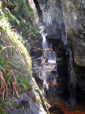
Unexpected features such as this waterfall make exploring the 'canyons' of the high moors southeast of Inverness a highly rewarding pastime
Geologically, the area is defined by the extent of granite rocks dating from the time of the great Caledonian Mountain chain, around 400 million years ago.  The area is bounded to the south by the River Findhorn; to the west by the A9 corridor; to the north by the River Nairn. To the east it loses altitude and peters out into farmland and forestry. It is an area of rounded hills with small exposures of ice-scoured granite on their summits. On the slopes and in  the hollows between lie vast quantities of glacial till, earth and rock deposited by glaciers and by the floods that accompanied their eventual melting. The defining feature of the area are the deep, steep sided channels that drain the high ground to all compass points. 

Evidence of an interstadial - peat sandwiched between layers of sand and gravel, Allt Odhar.
These channels are dramatic features, really gorges or ravines. One that contains a site of tremendous interest is the one that flows eastwards towards Moy, the Allt Odhar. It contains an interstadial site - evidence of a relatively warm period during an ice age when the ice receeded sufficiently for vegetation to briefly gain a root-hold. This is laid plain to see in the exposure on the banks of the Allt Odhar, which at first look like any other: capped by a layer or dark, heather-covered peat, from which protrude the bleached roots of bogwood - the preserved remnants of trees that were overwhelmed when the climate deteriorated. Below this is a crumbling bank of sand, gravel and stone, ice transported debris. But look closely and you will see a second layer of peat sandwiched between the till. This is the evidence of the interstadial and it has been extensively studied by those who take an interest in such things. They have found evidence of the past climate, the pollens of grasses, shrubs and -unusually for such a deposit - birch trees.

A further site of interest is to be found on the slopes above the great neolithic monuments at Clava Cairns, the Clava Shelly Clay, a clay deposit containing the shells of arctic shellfish that has been a source of valuable raw material and more recently, within the last 100 or so years, the subject of academic debate. It was originally held that the shells provided evidence that the area was once under the sea but lately, as it has become accepted that the sea level was never sufficiently high for this explanation to be correct, an even more fantastical explanation has found favour. The shelly clay are now believed to have been deposited on the seafloor between the village of Dores on the banks of Loch Ness, - now famous as the site of the Rock Ness festival - and Inverness when the relative sea level was much higher than at present. A great raft of this submarine clay, along with its cargo of shells, was gouged up by the ice stream that flowed down the Great Glen towards the Moray Firth. Before it could reach the sea it was deflected to the south by the rival ice stream that poured down the Beauly Firth, carrying vast volumes of ice from far to the northwest. It was deposited on the flanks of these hills where the puzzle it contained lay unsolved for millenia.

I usually access the hills from the Clava side, it being closest to my home.  Good landrover tracks lead over the summits of Beinn Bhuidhe Beag and Beinn Bhuidhe Mor, each providing a hill run of just under 10 km. These tracks are for the benefit of grouse shooting, for which the area is intensively managed. The heather is burned and sprayed to provide fresh growth for the birds. The hills are dotted with grouse butts, walls of turf or rock behind which the shooters lurk while the birds are driven towards them. I have remarked before that such tracks are often useful for recreational purposes, but that such utility is entirely accidental. For example they are generally used to provide access to the grounds of one particular estate. There is little incentive for estate owners to link their roads or path and in doing so to provide the type of long distance through routes that would be of great use for running or mountain biking. 

Grouse shooting has a sinister side, the poisoning of raptors and the trapping of ground dwelling predators of the grouse. An employee of this very estate - the Moy Estate - was recently successfully prosecuted for killing a red kite. This was not an isolated incident. According to the linked story in the Ross-Shire Journal, over a five week period, the remains of a further two dead red kites, six illegal baited spring traps, a trapped hen harrier, and a poison bait laced with a banned agricultural pesticide were also recovered from the estate. Disturbingly, no arrests or charges were made in connection with these additional incidents. I have my own story about illegal trapping on the Moy Estate which I will tell in a future post.

The River Findhorn east of Ruthven with the steep flanks leading up to the moorland containing the Graham summit of  Carn nan Tri-tighearnan


At the weekend I enjoyed a family picnic near Ruthven on the River Findhorn. We watched salmon leaping in a deep pool, some clearing the water completely. In the shallows upstream a seagull enjoyed its own picnic, pecking at the pink flesh of a fish who had come unstuck while impatiently trying to make his way upstream when the water level was insufficiently high. This provided me with the opportunity to make my own way home by bike, traversing this region of high moors from south to north, a pleasingly linear journey of 20 km or so, all but 3 km of which was on good tracks, with numerous exciting splashes through fords at the base of steep downhills. The trackless section was a tangled, springy mat of various lichens that I found reminiscent of Rondane National park in Norway. As is often the case, while actually pushing I vowed that it was an experience that I would never repeat, as soon as it was over my recollection was that it was not nearly as bad as I had expected. 

The Rondane-like, lichenous trackless section between the Ally Odhar and Beinn Bhuidhe Mor. The landrover track I'm heading to is visible to the left of the summit
It is always a great pleasure to arrive at a familiar place from a new direction, and it was a surprise  when, after 13 km or so immersed in this high and empty country, I reached the summit of Beinn Bhuidhe Mor and saw the land fall away to the Moray Firth. The view from this top is spectacular, the city of Inverness lies below, ringed by distant mountains; the hills of Affric, Strathfarrar, Strathconon, the Fannichs, Ben Wyvis, the Caithness hills. I am pretty sure that even  Slioch, a full fifty miles west as the crow flies, can be seen. This panorama will, thankfully, remain unmolested by the proposed windfarm development at Moy, but the view south into the great northern coires of the Cairngorms will surely be compromised. 

Hazy cloud masks the mountain panorama. Inverness and the Inner Moray and Beauly Firths from Beinn Bhuidhe Mor 
If you aspire to complete the Grahams, my advice would be to climb Carn nan Tri-tighearnan sooner rather than later, before the coming of the turbines. They cynic in me can't help but feel that windfarm developments present a win win situation for the proprietors of sporting estates. Not only can they line their pockets with the generous incentives provided, the turbines also provide a convenient way to persecute raptor populations without any risk of ending up in court.


Labels: , , , ,

Tuesday, 19 April 2011

Culra Bothy

Culra bothy with Ben Alder beyond
I've been wanting to get into Culra for quite some time so when a couple of friends announced that they were heading in for the weekend I decided to join them for a night and have a day on the hill. I left home after dinner and arrived about 2130 just as the light was fading. For such a remote location it is incredibly accessible - the 15 km cycle to the bothy from Dalwhinnie took me a mere 1'23''; I took it pretty easy because I had my dog with me and there is a fine line between giving him a good run and animal cruelty. Without a dog I reckon it could be done comfortably in an hour.

The approach down the side of Loch Ericht is a breeze on account of a well-maintained road that provides access to a variety of extravagant gothic buildings. The one closest to the camera is a mere gatehouse; the castle beyond is partially obscured by the trees.
Culra is one of the few bothies that is genuinely useful as a base from which to hillwalk or climb. Consequently it has a reputation for being crowded, despite having three separate sections. I had planned to kip in my new tent in an effort to drive the per night cost below that of a Hilton hotel but a light drizzle dissuaded me from leaving the warmth of the bothy. The bothy was quiet on Friday night, with only our party and a couple of guys camping by the river.

All in all it was a fine weekend and one that has inspired me to pay a few more visits to this part of the Highlands.

Labels: , ,

Monday, 11 April 2011

A Lightweight Epiphany in Glen Affric

The one that got away. Mam Sodhail and Carn Eighe from the ridge of Sgurr na Lapaich, 23rd April 2006
It may seem contradictory for one who purports to take a dim view of the pastime of Munro bagging to keep a careful record of his own ascents, but that is exactly the position in which I find myself. This noncommittal approach has led to me skipping some summits where a more dedicated bagger would have pushed on.  I've had it in the back of my mind for some time to return to Glen Affric to nab Carn Eighe, a hill that got away back in 2006. Looking back at the photos I'm not surprised that it escaped. I'd been experimenting with the lightweight, wearing approach shoes and crampons instead of boots. What I hadn't realised was the extent to which the nubuck outers of the approach shoes would wick moisture under my gaiters onto my socks. By the time I reached Carn Eighe's companion summit, Mam Sodhail, I could feel the makings of a blister. I bailed out down the ridge of Sgurr na Lapaich instead of making the return journey to the summit of Carn Eighe.

Campsite in Gleann nam Fiadh
It was fitting that the weekend's return visit marked a further journey into the world of the ultra light. Over the course of the last two years I've been developing a taste for solo trips. This started with a trip into the head of Loch Monar in my pre-blog days. Since I've been blogging I've taken a couple of solo trips, a winter bivvy and a spring trip into Fisherfield last year My only successful previous attempts at the ultra light have been bivvy trips. For camping trips I've always had my packweight boosted by a 2.75 kg two man tent and while it is quite possible to haul the resulting load over the hills it has been something of an exercise in masochism. Climbing hills is just so much easier without a 15 kg sack; one can easily spending several days completing a route that could be done - and enjoyed - in a day by the unencumbered. I enjoy spending time on the country as much as I enjoy climbing hills so have always been able to justify the inherent inefficiency of this approach to myself.

Mam Sodhail and Carn Eighe from the east, 9th April 2011. Much less snow this time.
All that changed last week with the arrival of Terra Nova Solar Competition a one man tent. At 1.15 kg it saves me a full 1.6 kg in tentage, but that is only the tip of the weight saving iceberg. Carrying less tent means that I can strip the lid and backplate from my pack, shedding a further 500 g. The danger with a heavy pack is that it is easy to stick more into it. With a light pack the reverse is true. All in all I ended up with a pack weighing 9.5 kg, under the all important psychological 10 kg barrier. If that sounds a lot it is because in addition to the essentials I was carrying a dog bed (required to prevent dog from moving around the tent), dog food, trekking poles and a heavy Canon G10 camera.

Carn a'Choire Ghairbh reflected in Loch Affric
I left Inverness just after 1800 on Friday night. By 2100 I was 7.5 km from the road in Gleann nam Faidh, relaxing in my tent with a warm drink. Saturday morning dawned fine and I was on the move by 0700. I paused for a brew on the summit of Carn Eighe at 0900 and was back at the car by 1200, having chewed my way through 24.5 km in under 6 hours moving. I arrived home just after 1300, satisfied and ready for an afternoon of family activity and gardening.

To complete the same itinerary as a daytrip by noon would involve leaving home at the unpalatable hour of at 0400 so this approach is actually an efficient means of travel, combining most of the speed of the day hike with all of the pleasures of backpacking. I've seen the light and can see why there are so many blogs devoted to this most satisfying of outdoor pursuits. I'm keen for more of these short fast trips, designed to spend maximum time on the country while minimising time away from family.

I'm in the market for a lightweight dog bed if anyone knows of such a thing??????????

Publish Post

Labels: , ,

Tuesday, 1 February 2011

Animal Rescue on Stac Gorm, Loch Ruthven

My heart sank as I watched Tam, my faithful border terrier, disappear from view, silently swallowed by the heather. I knew that we were in the vicinity of a deep cleft in the rock. Clearly it extended further than I had realised, overhanging heather completely obscuring its upper reaches, a fiendish trap lurking on the seemingly innocuous summit of Stac Gorm.

A frozen Loch Ruthven from the windswept summit of Stac Gorm.  Danger lurks to the right, just off camera.
With some trepidation I peered into the rift in the rock. It was close to five metres deep but only about twenty centimetres wide. A big enough drop to seriously injure a dog and so narrow that recovery would be extremely complicated, impossible without specialised equipment. As I scanned the gloomy depths, a distant corner of my mind was imagined how the birch branches by the lochside below could be cut to make a hooked pole of sufficient length to hook his collar. A wave of relief surged through me as I made him out walking unsteadily along the floor of what to him was a slot canyon. The far end of the cave was partially filled in with a ramp of earth and his fall had been no more than two meters. 

 I remembered from a previous visit that the slot had an accessible front entrance, making the evacuation of an uninjured dog a distinct possibility. As I slid down into the crevasse Stephen cautioned me not to get stuck, likening the developing situation to the recently released film 127 hours, the story of Aaron Ralston, who hacked his own arm off with a pen knife after it became trapped by rockfall during a canyoning trip. The entrance was a short dogleg, so I wriggled my way down and along between the tapering rock walls to get a look into the main chamber. Tam was about ten feet back, hesitating on the cusp of a constriction, fearful of  getting stuck as he squeezed himself through. I knew exactly how he felt. He panicked and managed, with some difficulty, to stand on his hind legs and turn round, ending up facing the wrong way. No amount of cajolling would convince him to reverse the maneuver. There was no way I could reach him, and even if I could get him to walk up to me getting him out would be very difficult. I was thoroughly wedged in and could not get two hands into the same place to lift him towards the exit. 

I eventually enticed him from the depths by jangling his lead, then somehow managed to bring him with me as I wriggled awkwardly towards the entrance. I handed the lead to Stephen and took the dog's weight with one hand as he was hauled to the surface, squinting like a Chilean miner.

Returning to the surface after a successful rescue, dazzled by the light after spending so long underground.


Labels: , ,

Monday, 3 January 2011

Solar Arc

We are blind to much of the wonder of the natural world. The beauty of great nature writing  is that it can open our eyes to this unseen splendour and provide us with the vocabulary needed to describe phenomena which might otherwise pass us by.

In his book 'Arctic Dreams' Barry Lopez describes how reflection and refraction of light by ice or water particles in the polar sky can give rise to a variety of arcs and halos. The most spectacular is the sun dog, rainbow patches that appear 22 degrees from the polar sun. You can see from the picture in the link that the sun dogs describe two opposite edges of an incomplete circle. This image shows a complete solar halo. Lopez notes that such features can also be observed in the part of the sky directly opposite the sun and that they are not limited to the polar regions, also being observable in the temperate latitudes. This piqued my curiosity and I have been on the lookout ever since.


Two days after Christmas I photographed the solar arc above while descending from Cul Mor in Assynt. It is in the sky to the north, directly opposite the late afternoon sun. It's a pretty subtle effect and would have been easy to miss had I not been primed by reading Lopez's book.

It was a grand day to be on the hill; still, though not as clear as had been forecast. Some high cloud resulted in the landscape being selectively illuminated by shafts of light, further accentuating landscape features that had already been rendered unusually prominent by a combination of low winter sun and residual snow lying in the gullies and hollows.

North to Suilven, Quinaig and Canisp from Cul Mor
To the south, in front of the Fannichs, a curtain of cloud spilled a low ridge. Sgurr Mor is prominent just right of centre.

South to the Fannichs from Cul Mor


Labels: , ,

Saturday, 16 October 2010

Knoydart, Knapdale and the Northwest

Last week I indulged in an extremely risky activity - I allocated  a week's precious annual leave to holiday in Scotland in October. The gamble paid off; my week coincided with something of an Indian summer. The photos accompanying this post give a flavour of the highlights.................

The week kicked off with trip to Glen Pean for a bothy weekend. This leaves Kinbreak as my only outstanding Knoydart bothy. It was a fine weekend, echoing a similar trip last year, only this time round all of us had abandoned young families and the morning lie ins were that much sweeter as a result.

On leaving the bothy I made directly for Kintyre to meet up with my own family. We took a trip to Knapdale in an attempt to seek out another young family; I was aware from the excellent beaver blog that some of the recently re-introduced beavers have produced kits this season. We didn't spot any but were very impressed by the huge dam they have built (below). I'll definitely be back in the hope of clapping eyes on the beasts themselves.


This photo of pounding sea and perching shags was taken during a stroll round the Coves near Kilberry Head. I can't quite bring myself to take advantage of the opportunity for double entendres provided by this unlikely combination of beaver and shags, feel free however  to add your own as comments below.

The paps the paps are calling me.......... The paps of Jura from near Kilberry.

The Islay ferry from the same vantage point. I have started plotting an adventure that will take full advantage of the presence of willing babysitters a stone's throw from the ferry terminal at Kennacraig. Watch this space!

The icing on the holiday cake came on the last day. I returned home slightly ahead of family and livestock and on finding a fine forecast for the Sunday I headed for An Teallach. (the photo shows the view over Strath na Sealga to Beinn Dearg Mor with the Fisherfield and Torridon Munros beyond).

Despite living very close to this fine peak I'd never climbed it before. There is some fine airy scrambling to be had on the ridge which renders it a poor choice for dogs. Many's the time I have planned to bag it, but finding myself unable to leave my four-legged friend behind, I've changed plans and tackled more canine friendly hills instead.  My fisherfield trip earlier in the year was dog-free specifically because I intended to tackle An Teallach on the last day, but when it came to it I couldn't muster the energy to take on the pinnacles while carrying a heavy sack. It was, therefore, unfinished business. With a distinct chill in the air it felt like it may have provided a fitting end to the summer season.


Labels: , , , , , ,

Monday, 5 July 2010

Cairngorms: Carn A'Mhaim from Lin of Dee

The southern approaches to the Cairngorms have a charm all of their own, the crunch of granite gravel under the mountain bike tyre, camping amid great stands of Scots pine. All in all a more leisurely and dignified experience than rushing towards the ski infrastructure from the Coire Cas car park to the north.

A fresh perspective on a familiar hill. Ben Macdui from Carn A'Mhaim.

Heading east was the only sensible option given the weekend's weather forecast and what a treat it was, a chance to spend time on some previously unseen country and to catch up with some old friends at the same time. A pleasant change from last weekend's solo trip, and my first visit to the Cairngorms since the last ski trip of the year in May - it seemed incredible in the cooler days of spring that such as vast quantity of snow would simply melt away, but melt it has in this particularly warm and dry summer. 

Campsite in Glen Derry, more reminiscent of North America than of Scotland 

There is something wonderfully subversive about drinking in the great outdoors, free from the roving eyes of CCTV cameras and the influence of authority figures. When you strip away the commercialism and regulation of city fleshpots – the queues, the curfews, the dress codes, the cover charges - all that remains is a raw, primal drinking experience. 

Or so we thought. Imagine our surprise when our camp was visited not once but twice by just such an authority figure, a representative of the National Trust for Scotland, owners of the Mar Lodge Estate. On his first round of the various campsites scattered round the glen he passed on his employer's objection to campfires. On his second visit, an hour or so later, he was armed - almost unbelievably - with a bright yellow bucket full of special ember-dousing water. It must have been special water for it to have been worth his effort to carry his full bucket several hundred metres from his Landrover, rather than using the water from the burn adjacent to our camp.


Labels: , , ,

Tuesday, 29 June 2010

36 hours in Fisherfield


Those familiar with the Scottish countryside will know that the Fisherfield Forest is misleadingly named, for it is not a tree forest but a deer forest, a historical term for a hunting ground. My weekend visit to this remote and spectacular region presented an opportunity to commit fully to the concept of the Bushbuddy wood-burning camp stove.  I was slightly nervous about striking off into this practically treeless wilderness without any fuel; the penalty for failure would have been crunching my way through uncooked dehydrated stew and washing it down with cold coffee

I decided on a through route, starting near Loch a'Bhraoin,  taking in the remote summits of Mullach Coire Mhic Fhearchair, Beinn Tarsuinn, A'Mhaighdean and Ruadh Stac Mor before walking back to the road at Corrie Hallie. My main objective was to spend some time on the country so I carried a tent and spent two nights enjoying the solitude of the wilds.

Reflections on Loch a'Bhraoin, 2300 hrs Friday night.  The weeks around the solstice are among my favourite of the year.

I was heartened to see cattle ruminating on the flanks of the lochside moraines as I walked the shore.  It filled me full of nostalgia for the sheiling days of pre-industrial Scotland, when  one could enjoy a summer making cheese in a hovel to the melody of lark and pipit. Though I sometimes lament the enforced industry of my current capitalist lifestyle, I would not swap it for transhumance. It is easy to take a rose-tinted look back and see only the availability of leisure time, forgetting that it was tempered with a lack of opportunity and the spectre of famine and disease. That said, our experiment in capitalism has not been in progress long enough for me to be confident that it will prove to be superior in the famine avoidance stakes.

A sandpiper accompanied me along the lochshore, shrilly crying in defence of eggs or chicks. Probably it was a dozen or more working in relay, but so tightly defined were their territories and so smooth were their changeovers that it seemed as if a single bird escorted me for the full 6 km length of the loch.


A riot of colour. The yellow is tormentil, if you know the the pink and blue please leave a comment and save me having to look them up.

A close of the blue one to aid identification


Meallan an Laoigh, Loch an Nid and a distant An Teallach from the east ridge of Mullach Coire Mhic Fhearchair.

I was very taken with this island in the sky, a little table-land of Torridonian sandstone on the ridge of Beinn Tarsuinn. If I was a rock star I would take my band up there and shoot a video.


Near the summit of a'Mhaighdean looking towards the unusual low ridge of Beinn Tharsuinn Chaol with the great cliffs of Ben Lair and the Torridon hills beyond.

A'Mhaighdean summit, where I met a guy who'd run in from Poolewe, the only person I saw all day. View down Dubh Loch and Fionn Loch towards Poolewe.

After more than 11 hours on the go I was glad to get my pack off, set up my tent up and get a brew on. Gleann na Muice, An Teallach beyond


Shenaval bothy on Sunday morning, living up to its reputation as one of the most crowded in Scotland. Beinn Dearg Mor in the background.

All in all an awesome trip and great to get the Munros nabbed after the weather forced me to content myself with a lesser prize last time round.  To my great relief the Bushbuddy was a tremendous success - a genuinely viable lightweight alternative to gas, even in the barren Lewisian environs of Fisherfield.


Labels: , , , , ,

<data:blog.pageTitle/>

This Page

has moved to a new address:

http://livingmountain.net

Sorry for the inconvenience…

Redirection provided by Blogger to WordPress Migration Service