Tuesday 27 December 2011

Landscape and identity: Bruce Chatwin's 'The Songlines'

Wildflower meadows at the base of Uluru (Ayers Rock). The photos that accompany this post were taken when I traveled in Australia in 1998
My plan when I started this blog back in 2009 was to use it to as a platform on which to explore the connections that exist between landscape and identity. Such connections are abstract and intangible; consequently I have touched on the topic infrequently and obliquely. A recent work trip to the US provided me with the time and space to re-read a favourite book that has a lot to say on this subject, Bruce Chatwin's 'The Songlines'.


Published in 1987, the book describes Chatwin's travels among the Aboriginal peoples of the area surrounding Alice Springs in Australia's red centre. He gained access to these normally reticent people courtesy of Arkady, who was surveying the route of a proposed railway between Darwin and Alice Springs, working with the traditional owners to identify their sacred sites so that the railway could be built with as little adverse publicity as possible. 'The Songlines' paints a vivid picture of the country and its inhabitants. But it is more than a travelogue, along the way Chatwin lays out his ideas on nomadism and on the roots of human aggression. Almost twelve years had elapsed since I read  'The Songlines'  for the first time. The aspect of the book that stuck with me over that time was its description of the Aboriginals' deep and complex relationship with their land, which I will attempt to summarise below.

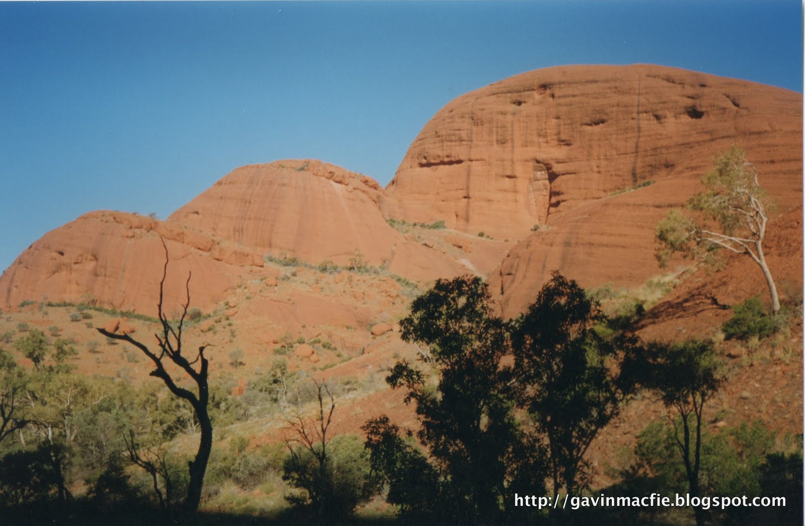
Kata Tyuta (the Olgas)
The song lines or dreaming tracks are known to the Aboriginals as the 'footprints of the ancestors', legendary totemic beings that wandered over the continent in the Dreamtime, singing out the name of everything that crossed their paths, singing the world into existence. The ancestors were generally animals; for example kangaroos, echidnas, budgerigars, ants or termites. The ancestors fashioned themselves from clay and traveled through the country scattering a trail of words and musical notes along the line of their footprints. The concept of going on walkabout - disappearing into the bush for weeks or months on end - was popularised by the film 'Crocodile Dundee', however I don't recall Paul Hogan mentioning that when an Aboriginal goes on walkabout he retraces the steps of his ancestor and sings the ancestor's songs, recreating the Creation. For the Aboriginals the land existed first as a concept in the mind, only once it had been sung did it really exist. 


Everyone inherited, as his or her own private property, a stretch of his or her ancestor's song and the country over which the song passed. A man's songs were the title deeds to his territory. One may lend or borrow song, but never sell or destroy them. Stops are handover points where the song passed from one's ownership, perhaps to a member of a neighbouring tribe in who shared one's dreamtime ancestor. Elders would advise travelling only 2 or 3 stops down the songline, but man may acquire ritual knowledge, thus extending his song-map and his territory. If a man strayed from his songline without first acquiring the necessary songs, he was trespassing and could expect rough treatment - even a spearing - from the owners. But if he had the song he could rely on their hospitality.


Most tribes speak the same language as their neighbours, or at least a similar one. However, song cycles may pass through many language barriers, for example following lines of reliable waterholes from Broome in the Northwest right through the centre to Adelaide in the South, passing through 20 languages en route.  For example in 1900 an Arnhemlander walked from his home, northeast of Darwin, to the south coast. There he found a wife, who he took home to the opposite side of the continent. Her brother accompanied them on the return journey and did the reverse.


The stone country of Kakadu National Park
The real mystery and beauty of the songlines is that an Aboriginal would be able to recognise the land being sung by a member of another tribe from a thousand miles away, despite not knowing a word of the language in which the song was sung. Chatwin reported that at least three theories had been proposed. Firstly there was telepathy. Secondly there was something that sounded like astral projection or the shamanic 'flying' described by Carlos Castaneda.  Lastly, the most likely explanation, which is that the land itself was encoded in the melody and rythm of the song. The melodic contour describes the lie of land directly, geographical features were rendered in particular note combinations. For example a listener would be able to count the number of river crossings or changes in gradient and pick out the precise position on a songline. The music of the dreamtime was thus a memory bank for finding one's way about the world. Chatwin tells of accompanying a group of Aboriginals in a Toyota Landcruiser, bumping along a dirt road. He noted that one of the men was singing very quickly, his lips a blur. The cadence of his song altered with the speed of the vehicle, suggesting that his song described the country in real time, at walking pace.


In Aboriginal belief an unsung land is a dead land: if the songs are forgotten the land itself will die. Periodically the elders of a totemic clan may decide that it was necessary to sing their song cycle from beginning to end. All owners would assemble at a 'Big Place' and sing their sections in order. A Big Place would be a significant landscape feature, such as those in the photographs that accompany this piece, Uluru, Kata Tyuta, Kakadu and Karlu Karlu. Many songlines would converge at a Big Place making them important for trade and for arranging marriage between members of different tribes.


The Aboriginals of Australia are unique in having maintained a stable and mature hunter gatherer society for tens of millenia, perhaps fifty thousand years. Hence their beliefs may provide the best window available into the minds of our own distant ancestors. There are other constructs that are remeniscent, to some, of the songlines: Britain's ley lines; the dragon lines of Feng Shui; Lappish singing stones; the Nazca lines of Peru. Yet Chatwin felt the songlines not be be a peculiarly Australian phenomenon, but to be universal; that they were the means by which man had marked out his territory and organised his social life. All other successive systems were variants - or perversions - of this original model.


The main songlines in Australia appear to enter the country from the north or northwest - from across the Timor Sea or the Torres Strait - and from there weave their way southwards across the continent. It is possible - perhaps probable - that they represent the routes of the first Australians as they traversed the country around sixty thousand years ago. Chatwin presented an enchanting vision of  songlines stretching across the continents and through the ages, speculating that wherever men have trodden they have left a trail of song, and that these trails must reach back in time and space to the region in Africa's Rift Valley from which all modern humans originated. 


Karlu Karlu (the Devil's Marbles)
We may  now and again catch an echo of these trails of song. Chatwin speculated that the whole of classical mythology might represent a totemic geography of the ancient world. I have not read his later work and so don't know if he was able to expand on these ideas prior to his death in 1989. It strikes me that these echos may even be audible in Scotland, that through legend and placenames it may be possible to reach back through time and to see into the minds of the first hunter gatherers that migrated into Scotland at the end of the ice age, eleven thousand or so years ago. 


This may seem far-fetched, but let me give you an example of an echo that I heard on my recent trip to the Isle of Jura to view the Corryvreckan whirlpool. Corryvreckan has been translated as ‘cauldron of the plaid’. The plaid in question was owned by the Goddess of Winter, Cailleach Bheur.  As winter approached the Cailleach could be heard washing her plaid in the swirling waters of the Corryvreckan for three days – possibly a reference to the enhancement of the whirlpool’s roar by the equinoctial gales. After such treatment the plaid was pure white and became the blanket of snow that covered the land. Placenames containing Cailleach are common in Scotland and are often translated as 'old woman' or 'witch'. But could it be that all these Cailleach landscape features are linked to ancient legend, and that a route connecting them might trace the path taken  by some form of dreamtime ancestor and by inference the migration routes of the first Scots?


I'm going to finish by restating the Aboriginal belief that an unsung land is a dead land: if the songs are forgotten the land itself will die. I visited that wild west coast of Jura twice in 2011 and both times I  publicised it online through word and picture (see the first visit here). Being actively involved in the popularisation of wild places makes me slightly uneasy, for part of the attraction of these places is that one can count on not meeting other people. But I believe it is also important to spread the message and keep the place alive, after all would I even have been there had W.H. Murray not inspired me by writing of his visit? For me that rugged coast will always be there, and it will always be important. But if no-one ever went there, if its beauty remained unseen - and it has been seen less and less over the centuries - at what point could it be said to no longer exist in any real sense? As I stood alone atop the flat-topped stump of Aros Castle behind the Glengarrisdale bothy, admiring the view out to sea and thinking these thoughts with the wind in my hair, I would like to think that in some small way I shared the feelings of deep reverence and connection with the landscape that an Aboriginal experiences as he sings his country into existence.


Glengarrisdale Bothy, Isle of Jura


Labels: , ,

Tuesday 6 December 2011

Another night march to Maol Bhuidhe

Maol Bhuidhe and a snow-dusted Lurg Mhor
Maol Bhuidhe bothy lies in the heart of the great roadless quarter between the Road to the Isles to the South and the Lochcarron road to the North. It is a strong contender for the title of Scotland's Most Remote Bothy, and this inaccessibility, coupled with the many references to it in Ian R Thomson's 'Isolation Shepherd' gives it a tremendous sense of place. It has become a firm favourite of mine, a place that I know I will return to again and again for as long as I have the necessary fitness.


My friend Dave and I have become the sole participants in an esoteric but highly rewarding sport. The simple objective is to get into Maol Bhuidhe on a Friday night in the depths of winter. We've been in twice before, using a different route each time. Both times we arrived between 0200 and 0300 on Saturday morning, very tired and pretty close to the ends of our tethers.   We set out on our third route expecting it to be hard, but thinking that it couldn't possibly be any worse than the previous attempts. Deep down I knew that the second had been harder than the first, so why shouldn't the third be worse still? Just to ensure good sport we made our customary late start and loaded our bags to overflowing with beer and coal. You can read about the first two visits here. 


The three approaches tried so far. The most recent is in green.
The conditions we experienced on Friday night could not have been more different to the icy, starlit  approaches of previous visits. Horizontal rain blasted us from behind. The temperature was close to freezing, but warm enough for the rain to wash away the snow that had fallen earlier in the day. This year's route started at Killilan, but instead of cycling east up Glen Elchaig, as we had done on our first visit, we followed the River Ling to the north. We left our bikes in the deer shit-filled tin shed in Coire Domhain, which I found reminiscent of Breacan's Cave on Jura. From there we struck over the high ground towards Bealach Luib nam Feedag before dropping down to meet the path from Glen Elchaig. Compared to the other approaches it is shorter, and satisfyingly direct, but we were to find it the most testing of all.


Roaring water made itself audible over the wind as soon as we left the tin shed. Almost immediately we had to cross a wide, fast-flowing burn. It was clear that there was no easy way over and we decided just to accept wet feet and wade across rather than going off route to blunder about upsteam in the hope of finding an easy fording point. The crossing felt challenging in the fast-flowing water.  When I looked back to watch Dave cross the water was half-way up his thighs at times. We then picked up a stalker's path that wound its way from Coire Domhain towards Bealach Luib nam Feedag. The path terminated at the foaming waters of the Allt a' Choire Dubh, which at first sight appeared impassable. At the first burn we'd been worried about wet feet, but this one looked ready to sweep us away. We prospected upstream and found a wider section to try. 


The burn in Coire Domhain as we found it on Sunday. I wish I'd had the presence of mind to photograph the rivers on Friday night but at the time just getting across them seemed more important.


The flow deepened and speeded up as we approached the far bank and, feeling that a dunking was a real possibility, I remembered the advice that one should loosening one's rucsac waist bands prior to crossing a river. As I undid my waistband in midstream my pack, which was top heavy with beer and coal, unbalanced me. I pitched forward, becoming partially immersed in the icy torrent of snowmelt, bracing myself with my poles. This increased my cross sectional area and the force of the water increased, pushing me downstream. As I tried to stand back up my pack tilted forwards, counteracting my efforts. The situation was reminiscent of being strung out during a climb; it was clear that I couldn't stay where I was, yet any movement brought with it the even less palatable possibility of a full immersion in the frigid waters. There followed a period of stalemate during which Dave overtook me and started hauling himself up the bank. The icy drenching unsettled me and I knew that I had to get moving to generate some heat. 


I was trialling navigation using the Viewranger GPS software, keen to see whether or not, when run on  a waterproof smartphone like the Motorola Defy+, it could make an adequate substitute for a proper GPS. It worked well initially but as the weather deteriorated it became increasingly difficult to operate, largely because I had forgotten to disable the screen lock and had difficulty with entering my password with rain hitting and activating the touch screen. I checked it regularly as we marched over sodden, trackless terrain, at times convinced that we could see Argo cat tracks. We followed a raging burn, all the while conscious of the very real risk of hypothermia and alert for symptoms such as disorientation and muddled thought. We were aiming for a fork in the burn but never seemed to get any closer to it. I realised that the GPS had cut out and that we were now further along and to the left of the bealach. It was cold with lying snow and an icy, rain-laden wind. There followed a short period of bumbling around the complex topography during which we contrived to contour round 180 ° and track about 200 m back the way we had come. After verifying our position with the GPS I abandoned my experiment with technology,  pulled map and compass from my bag and took a bearing, delighting in the simplicity and ease of use of the old-fashioned method. 


The terrain soon levelled and eventually began to slope down. The descent was surprisingly short, for it meets the path near its high point. We had to make a third river crossing to access the path. It was straightforward enough but on any other night it would have been worthy of comment. We picked up the track and marched on, cheerful at having put the worst behind us. Our margin for error had been reduced uncomfortably close to zero up on the high ground.  I wasn't short on energy but was concerned about the creeping effects of exposure. The burn by the bothy, innocuous on previous visits, provided a counterbalance to my euphoria at the first sight of its white-washed walls. It was a fearsome prospect. We scouted downstream. Dave announced that he was going for it and promptly fell in. In the bothy all was soaked by our dripping equipment.  


Crossing the burn at Maol Bhuidhe on Sunday morning under a leaden winter sky. The picture below gives an indication of how low the level was compared to peak flow on Saturday night.
We lit a fire and began to warm up. We both agreed that the approach had been one of the toughest ordeals we had endured. Previous approaches had been long and hard but the conditions were ideal, crisp and still. We were able to rest frequently and enjoy the stars and the groaning ice of Loch Calavie. There was no such option this time round. We had to keep moving to stay warm; there could be no rest, no warmth until we reached the bothy. I do not know how long we could have continued without suffering some ill effect and ending up in a bit of a predicament - probably much longer than one might think, the human body is after all capable of far greater feats of endurance than an sodden ten mile trudge with a heavy pack. We speculated as to what might have transpired had we invited a normal person - an unsuspecting work colleague for example - along on this trip, informing them, as we ourselves partially believed at the start, that we may make it to the bothy by midnight. I honestly don't know what would happen, they would certainly find the experience a bit distressing, I know I did. 


Of the three approaches this was by far the hardest, entirely due to the weather and rivers.  But by morning we were again plotting new approaches for next year, identifying several untried ones on the map. The Maol Bhuidhe magic was working again.  We ate a late breakfast then retired to doze until 1600, keen to conserve coal for the evening. Dave left bothy once with spade, I once to collect water. Snow drifted on the flanks of Ben Dronaig, outside and all around the rivers raged, I picked a marker stone in the burn and was pleased to watch the level drop considerably over the afternoon, then dismayed to watch it rise above its previous high point by bedtime. Thankfully the waters had receded by Sunday morning and return journey took a full two hours less than the approach.


This is the burn outside the both as we found it on Sunday morning. On Saturday night the square block was totally submerged and I suspect that it was in a similar condition when we arrived on Friday night


Labels: , ,

<data:blog.pageTitle/>

This Page

has moved to a new address:

http://livingmountain.net

Sorry for the inconvenience…

Redirection provided by Blogger to WordPress Migration Service