Wednesday, 8 August 2012

Journeying on the Isle of Islay

‘The act of journeying contributes to a sense of physical and mental well-being, while the monotony of prolonged settlement or regular work weaves patterns in the brain that engender fatigue and a sense of personal inadequacy.’
 Bruce Chatwin, Nomad Invasions, 1972

The Sound of Jura from Rhuba Bachlaig
Those of us who live in Scotland are almost uniquely fortunate in this crowded world in that we possess wild land aplenty in which to engage in the act of journeying. Our reserves are increasingly under threat from development, but for now there many areas where one can go with a reasonable expectation of passing a few days in complete solitude, without setting eyes on another soul.

The roadless tracts of Islay’s north eastern tip are one such place. The coast facing the sound of Jura is uninhabited north of the ferry port of Port Askaig, save for the distillery settlements of Caol Islay and Bunnabhainn and the lighthouse keeper's cottage at the point of Rhuvaal. As always before a trip to the islands I took my well-worn copy of WH Murray's 'The Hebrides' from the bookshelf to see what the great man had written about the place. To my surprise his otherwise exhaustive survey had neglected this corner of Islay. This pleased me and lent to the outing a feeling of exploration.

Rhuvaal Lighthouse
I cycled to Bunnabhainn then took the faint argo track which follows the path of the power line to the lighthouse.  I picked my way round the rugged north coast to the feature that had drawn me, the north facing sands of Bagh an Da Dhoruis, where I planned to make a camp from which to explore the caves and bays of the uninhabited north coast. The rain, which had fallen heavily throughout the crossing from Kennacraig and the cycle to Bunnabhainn, began to ease as I walked the coast and had stopped completely by the time I paused at the incongruous, isolated telegraph pole that marked the start of the easiest passage through crags of shattered limestone down to the bay with its stranded stacks and great arches. The pole was a true telegraph pole of the type that were replaced 20 or 30 years ago and which are now found only in the remotest of outposts, with three cross bars at the top, each holding four ceramic insulators. I can only imagine that it is the lone survivor of a line that once connected the islands of Oronsay and Colonsay, some half dozen or so miles to the north, to the mainland via a subsea cable.

I was surprised to spot a bothy further up the coast and checked my map. Sure enough, I picked out an ambiguous square feature of the type that might signify a house, a ruin or a large boulder that had passed unnoticed on previous inspections. Hunkering down, I reached for my monocular so as to conduct a more careful inspection. Scanning the foreshore only rocks were visible, but when I removed the glass from my eye the bothy returned. I was looking onto the corner of the building and could clearly see the gable end and the roof, complete with chimney. So convincing was the illusion that I alternated between the glass and the naked eye several times until I was sure that my eyes had indeed deceived me.
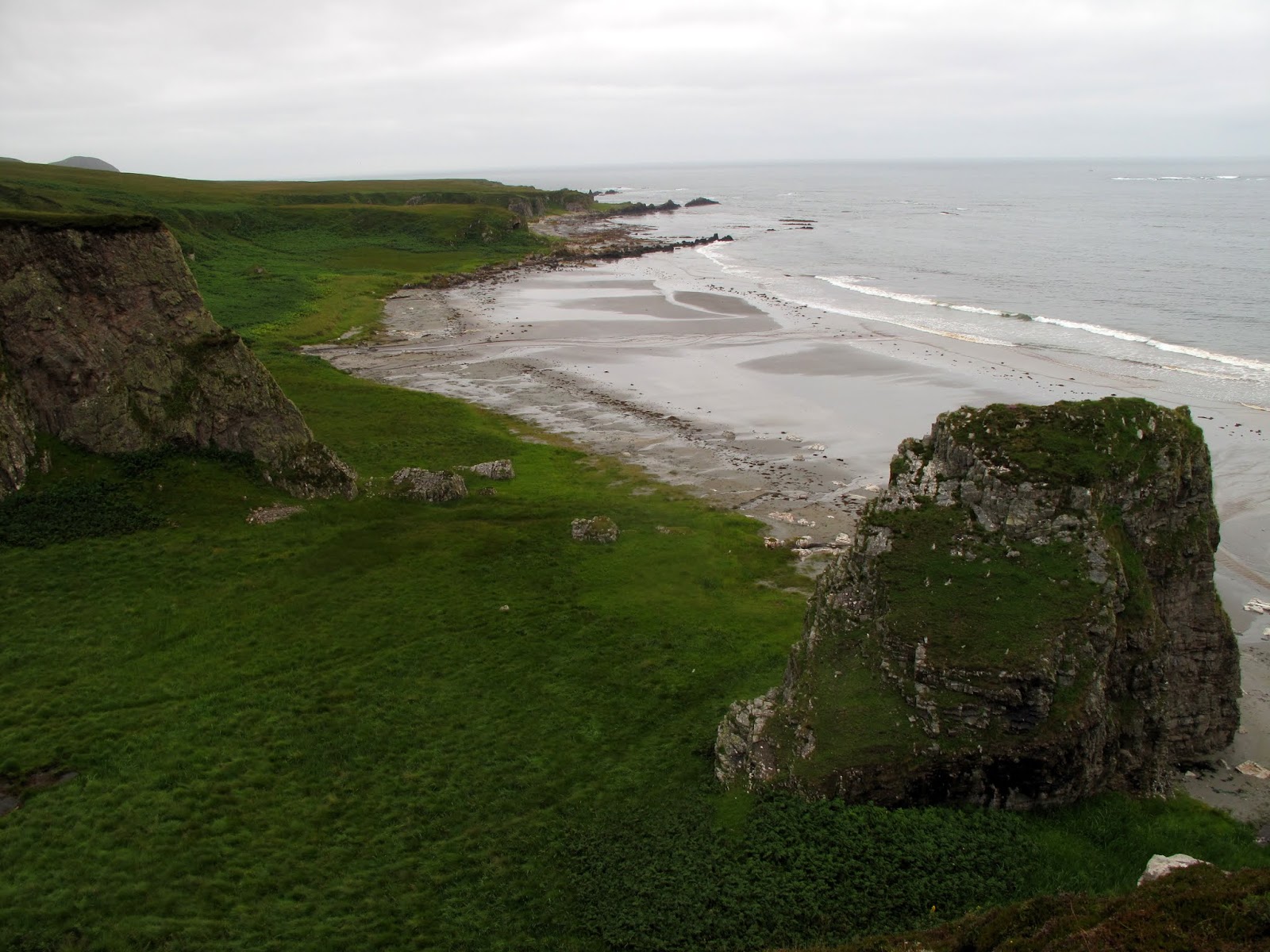
Bagh an Da Dhoruis
The bay rests within an amphitheatre of steep limestone crags. Between the crags and the sea lay a raised foreshore, the boggy ground of which supported verdant grasses, swaying gently at the peak of summer growth. A swell was running. The resulting waves folded themselves parallel to the kilometre of westward stretching sand. The afternoon's rain, peat-stained to a deep auburn, thundered from the moorland above in foaming cataracts and fibrous trickles. A pyramidal stack of limestone reared up from the grass, presenting a shear face seawards.

As I picked my way down towards the bay I felt I was entering a lost world. If a mirror had replaced the broad Atlantic views to the north I would have been descending into a crater. Echoes from the cataracts and the surf echoed off the cave-lined cliffs, providing a disorientating, swirling soundscape, often completely out of sync with visual input. More than once I heard what sounded like human cries within this tapestry of sound. All in all the place possessed an atmosphere which I savoured as I walked along the sand, periodically pausing to inspect likely camp spots.

Two thirds of the way along the sand I left the intimidating, wet atmosphere of the amphitheatre and rounded a small headland with a dry cave near its top to find a large expanse of classic raised beach. The goat-cropped machair was studded with purple thistles.  The grass was broken in places by stranded shores of cobble sized stones. A volcanic dyke extended its arm offshore and the waves struck it with explosive force. The slopes separating this from the upper moor were both smaller and less steep than those of the amphitheatre, leading to less reflected sound and a more restful ambiance. I pitched up and set about preparing coffee then dinner, passing the evening in meditative contemplation, drinking in the scene with all my senses. Far offshore the surf broke over hidden reefs. I watched as the evening light picked out the small hills and duns of Colonsay and Oronsay, triggering memories of a sunny May week spent exploring the beaches and small hills of the finest and most compact of all the Hebridean islands. To the west, beyond the jagged crests of the Post Rocks, lay the open Atlantic. The indented coast of Jura stretched eastwards, its raised beaches of melon sized quartzite rocks reduced to pastel strokes in the flat light. Beyond its tip the dark pyramid of Scarba squatted above the foaming waters of the Gulf of Coryvreckan.

Camp spot at Bagh an Da Dhoruis
The geology hereabouts provides insight into the climate of the distant past. The most striking rock is the quartzite whose white blocks comprise the Paps of Jura and also the higher summits of Islay. Similarity of appearance and geographical proximity might lead one to assume that it was formed, like the quartzite of the Northwest, in Cambrian times. But it is in fact more than one hundred million years younger, part of the Dalradian rocks that make up much of the Southern Highlands between the Highland Boundary Fault and the Great Glen Fault. The signature rock type of the Dalradian is a contorted, slatey mica-schist, but it also contains fine sandstones (quartzite), limestones and, most interestingly, tillites. Till is the mix of rock fragments and soil that is left behind in the wake of glaciers. Indeed much of the soil of Scotland can be described as a glacial till formed during the most recent ice age. Just as sand becomes sandstone, till becomes tillite, and that is what is found in the vicinity of Port Askaig, evidence of a past glaciation between 700 and 600 million years ago, when Scotland was located close to the equator. 

The formation of such glacier-milled soil near the equator has been taken as evidence of ‘Snowball Earth’, one of several episodes in the distant geological past where the planet has been almost completely encased in ice from poles to equator. Beneath this icy blanket, volcanic processes continued unabated, locally melting the ice and spewing carbon dioxide into the atmosphere. With the oceans hidden there  was no means by which this greenhouse gas may be removed from the atmosphere and it continued to build up, retaining the sun’s heat until the temperature increased sufficiently to melt the ice, thus freeing the planet from its frigid strait-jacket and raising sea levels such that the glacial till was submerged in shallow seas. In the warming climate water vapour evaporated from the ice-free ocean surface to form rain clouds. The rain scrubbed the carbon dioxide from the atmosphere to form acid rain which fell onto a landscape of bare shattered rock and soil exposed by the retreating ice. As the acid rain reacted with this landscape it carried the carbon into the oceans where it precipitated as limestone. Such limestones occur worldwide above Snowball Earth tillites and are known as cap carbonates. The Bonahavon limestone, of which the north coast of Islay is composed, is generally believed to be an example of a cap carbonate.

Kids playing grazing on a lichenous ledge
 The pounding surf lulled me to sleep after a three course dinner of soup, re-hydrated chilli and couscous and Angel Delight. I awoke to a bright day. The tide was out and the sea calm. My regret at not having fully savoured the rhythm of the waves was momentary, for when I removed my earplugs the otherworldly sound of seal song reached me. Out on the exposed rocks they were basking in the sun and communicating with one another in highly varied melodic bursts. In another life I could spend a summer camped here on the machair, kayaking amid the seals and recording their songs by day, attempting to decipher them by night round the campfire.

The still conditions brought with them a small contingent of midges and I walked out onto the shore while I ate a breakfast of porridge, gradually adapting to the realisation that an entire day stretched luxuriantly out in front of me and that I had nothing to do but please myself. I wrestled with the possibilities. The temptation to pass the day doing no more than mooching round camp was strong but an equal and opposite urge tempted me to strike camp and relocate myself further along the coast. In the end I compromised, packing lunch and setting off on an exploration of the coast. Initially I followed the highly indented coast, scrambling where required on the friable limestone and the more solid rock of the basalt dykes, but progress was slow. Wandering beneath arches into a hidden sea cave I found myself at a dead end and, rather than retrace my steps decided to scramble up and over the arch. As is so often the case I had soon made several moves that I really did not want to reverse. Fully committed I pressed on, hoping not to find my path barred by the impassable or the unjustifiable, all too well aware that should I fall I would lie broken in the geo below for quite some time. No alarm would be raised until I failed to return to my family the following evening. Given the remoteness of my location it would be at least 48 hrs before any search party found me. I pressed on and found that the arch culminated in an exhilarating knife edge. I shuffled across and was glad to step once again onto flat ground.

Port a' Chotain
Caves are numerous along this coast, both sea caves and, up on the raised beaches, stranded sea caves. Most are unwelcoming: wet, contaminated with decomposing deer or goats, or both. The extensive caves at Port a’ Chotain are an exception, rivalling Uamh Breacan on the north tip of Jura in their extent and dryness, but with superior camping possibilities on the flat grass outside.  They are marked on the map using the font reserved for antiquities, past habitation providing a useful guide to present habitability that is worth bearing in mind when plotting cave-dwelling excursions.

Mala Bholsa
From Port a’ Chotain I set my sights on the low but prominent hilltop of Mala Bholsa, and struck up from the coast onto the meadows surrounding the ruined farmstead of Bholsa. By the summit trig I brewed coffee, ate my oatcakes and cheese and considered my next move. Further along the coast was another marked cave Uamhan Donna, which I recall reading somewhere had been inhabited in recent times by a woman called Donna and was tempted to inspect.  But to get to it would necessitate a descent to boggy ground, so I decided to contour back round to my camp, keeping to the higher, drier ground as much as possible. The going was easy and I was soon back at my camp, chopping driftwood for my evening fire.

Bagh an Da Dhoruis with Colonsay beyond
Next morning, rather than repeat the boggy walk along the sound, I walked back out over the quartzite hill of Sgarbh Breac to Bunnabhainn. I cycled back to Port Askaig where I enjoyed a pint in the sunshine and watched the clouds clear from the Paps of Jura while waiting for the afternoon ferry. A couple of days of journeying had renewed me, leaving me ready to return to what Chatwin described as the fatiguing monotony of prolonged settlement and regular work.

The Paps from Port Askaig


Labels: , , ,

Tuesday, 6 September 2011

Benighted on Sgurr nan Ceathreamhnan

Mullach na Dheiragain from near the summit of  Sgurr nan Ceathreamhnan

I panted my way to the summit of Mullach na Dheiragain at 2030 hrs.  After fueling up on trail mix I rummaged in my pack for my head torch. The prospect of benightment didn't concern me in the slightest. After the short, light nights of summer, I was looking forward to renewing my acquaintance with the constellations as I strode along under the starlit sky, 

The torch was nowhere to be found. I realised with a sinking feeling exactly where it was - back in my camp, about 6 km away and 700 m below. Suddenly my impending benightment seemed to be a very serious predicament indeed. I had seen a small slither of moon low in the sky earlier in the evening so knew that  there would be no reprieve from a full moon; my error would not go unpunished. Less than an hour of usable twilight was the most I could expect before true darkness set in. I looked around and took stock of my situation. If you were to hand me a map of Scotland and ask me to point out the place in which I would least like to find myself alone, in the dark, without a torch, the place in which I now found myself would be a strong contender.  I was deep in the wilderness, at least 15 km from the nearest road in every direction.

It was clear that I had to move fast, to get down off the summit, traverse across to Coire nan Dearcag, then climb up and over the east ridge of Sgurr nan Ceathreamhnan to start the descent into Glen Affric.  The route would be on unfamiliar, trackless terrain, but I had prospected the initial section of the route carefully on the way out. I would make the coire before light faded completely. Once in the coire I knew that the east ridge would be silhouetted above me and I knew exactly where I had to cross it, on the left side of the third top. Once on the other side I may be lucky enough to pick up the stalkers' path. I hoped that I would see the light of the remote Alltbeithe Youth Hostel and that this would give me something to aim for. I made haste.

Campspot with Beinn Fhada beyond
It was very dark indeed as I began to scramble up from the coire floor to the ridge. I felt my eyes bulging open, as if by opening my eyes as wide as possible I could actually let more light in. I had Tam the dog on his lead a few feet ahead of me. It was possible to pick his body out of the surrounding gloom, thus providing a useful gauge of the aspect of the terrain. My plan had been to push on until I could see no more and then assess the situation. I had a mobile phone but was knew that using it would kill my night vision for at least 10 minutes. I wanted to save the battery in case I needed its feeble light during the intricate micro navigation that would be required to locate my camp.

The light of the hostel was not apparent on the initial descent from the ridge but the outline of Mullach Fraoch Coire on the other side of the glen provided a guide as to the correct bearing. Hitting some steep ground made me realise that I had to be exceedingly careful, I couldn't make a single step without being very sure that there was something to step onto. Darkness could hide anything from a tiny divot to a leg-breaking cleft or the edge of a cliff. I resorted to tapping the ground before me like a blind man to verify its solidity, even shuffling on my rear at times. As I weaved to and fro in search of an easy route I dreaded finding myself stuck on a crag with no option but to put on my coat and hunker down to pass an unpleasant night, waiting for the dawn. 

The lights of the hostel came into view, lending me great cheer and giving me something to aim for. The terrain hid them on a few further occasions and each time I fervently hoped that the guests had not retired for the evening, depriving me of my beacon. I blinked, trying to interpret a tall, totem pole-like object a few feet in front. I realised that it was part of the fence that encloses the burn above the hostel. Its purpose is to keep the deer from eating the young birch that are doing their best to replace those that originally gave the burn - and the hostel - its name, Alltbeithe. This provided me with a handrail with which I was able to feel my way down the slope. When the wire ran out I glanced above to where an embarrassment of stars and the milky way peeped between shifting cloud. The lights of the hostel were now close and the angle of the slope had eased off considerably. The worst of it was over. I decided to use my mobile phone display to negotiate my way back to the tent. The puny light did little more than illuminate the ground on which I stood but this was a tremendous improvement. With its aid I picked up the track and made straight for my campsite. I was practically standing on my tent before I could see it. I have never been so glad to see a tent in my life. The time was just before 2245 hrs. I had been on the hill for just under five hours but was was completely frazzled after concentrating so hard. I stretched in my tent with a brew, deeply satisfied at having successfully extricated myself from what could all too easily have turned into a right old pickle.

A'Chralaig and the ridge connecting it with Mullach Fraoch Coire

On waking next morning to the sound of rain I opened the flap to inspect the day. On seeing that a thick swarm of midges milled outside, waiting for me, I decided to return to sleep and didn't wake until after 1000 hrs by which time the sun was shining, a light breeze had dispersed the midges and all was well. I walked out over Mullach Fraoch Coire and A'Chralaig in beautiful conditions to round off what had been a splendid - and unexpectedly exciting - weekend amid the high peaks of Affric and Kintail.


Labels: , , ,

Wednesday, 13 July 2011

Isle of Jura backpacking and snake charming

The wild, uninhabited west coast of Jura captured my imagination when I glimpsed it between fleeting clouds from the summit of Beinn Shanntaidh two years ago. We returned at the weekend and made two traverses from the road on the east coast to the west. The first skirted the northern flanks of the Paps to Glanbatrick with its fabulous raised beaches, the second to the Glengarrisdale bothy near the north end of the island.

We saw only two other walkers the whole weekend, but there was plenty of wildlife. At Glenbatrick we watched a seal playing in the water, barking loudly when he surfaced and even breaching on a couple of occasions. At Glengarrisdale deer and goats infested the beach. The walking was rough, pathless bog and tussocky, waist-high grass. I saw one young adder, who knows how many I missed?

Having two encounters with poisonous snakes in the space of a month made me check what to do in the event of a bite. The advise from the NHS is remain calm, immobilise the affected limb to prevent the poison spreading then seek immediate medical assistance. It sounds like they usually just keep an eye on you in hospital anyway, so if bitten when right out in the wilds I'm not sure whether it would be best to sit it out or to push on in the hope of getting to a doctor or hospital.  

Does anyone have any good snakebite stories? I don't mean the lager and cider variety........

MV Finlaggan steaming between Kennacraig and Port Askaig

Sunset from Glenbatrick, Jura
Sunset from Glenbatrick, Isle of Jura
Glengarrisdale bothy, Isle of Jura
Campspot near Glengarrisdale bothy, Isle of Jura

Labels: , , , ,

Tuesday, 5 July 2011

Hilltop camp on Maoile Lunndaidh

Maoile Lunndaidh summit cairn, 0300 hrs
There's been plenty outdoor action this summer but no lightweight overnight dogwalks since April, when I tested my one man tent in Glen Affric. Ever since writing about the solstice a couple of weeks ago I've been like a coiled spring, possessed by a burning urge to take full advantage of the light nights. What motivated me in particular was a high camp, a chance to spend a night in the sky. The opportunity arose on Saturday night. The forecast was irresistible, cloud-free hills and light winds. 

Lochcarron hills from above the Allt a'Chonais gorge
Maoile Lunndaidh, a vast and remote hill to the north of Loch Monar is one that I've had my eye on for a while, having bagged all the surrounding peaks. It is perhaps not the most obvious choice for a quick evening ascent with a dog in the party, the shortest approach to the base of the hill being around 9 km up the Pollan Bhuidhe from Achnashellach, necessitating a mountainbike approach. As I packed I engaged in a constant fight with my lazier side as it tried to dissuade me from venturing out and to tempt me onto the sofa instead.

I left the house just before 2000 and an hour later I was setting off on the track that winds uphill below the great, gully-riven face of Sgurr nan Ceannaichean. The track climbs to a rocky knoll, avoiding the deep gorge of the Allt a'Chonais, before descending into the flat-floored upper glen known as the  Pollan Bhuidhe. After the effort of the ascent, still within earshot of the road and railway in Glencarron, the descent brings a liberating feeling of leaving the world behind, of dropping down into a silent netherworld. The name translates, as far as I can tell, as yellow poppy, which seems a strange choice or perhaps an incorrect translation. I love country like this, where the landforms themselves define the route, providing a natural and aesthetically satisfying path through the landscape. To my right the branching of alternative routes jogged memories of hill days past: the paths over Sgurr na Feartaig and up to the Bealach Bearnais, both of which provide fine routes into the great basin in which lie the Bendronaig and Bearnais bothies.

Camp spot on the summit
All is quiet in the Pollan Bhuidhe now, but in days gone by many travellers would have passed through,  following the old drove road from Poolewe to Fort Augustus. I followed in their footsteps as far as the peculiar trio of buildings at Glenuaig Lodge: the lodge itself; a sizeable turbine house; a small wooden bothy. The bothy is comparatively luxurious, boasting a bunkbed with mattress, electric light and - probably uniquely - electric heating courtesy of the adjacent hydro scheme. I could feel cabin fever building even in the 20 seconds or so that I spent inside and was glad to strike off up onto the slopes of Maoile Lunndaidh.

Loch Monar, early morning
I arrived on the pleasingly flat and grassy summit at half past eleven. The climb had been in daylight and I only just needed my headtorch to erect my tent. Once inside I became acutely conscious of the great mass of the mountain below me. It was a similar sensation to that felt when caving, or in the depths of a coal mine, but in reverse. When one is underground the awareness of such a mass of rock above is oppressive, alarming, claustrophobic. But when the rock is below, there is a liberating and intoxicating feeling of being pushed upwards into the sky and deep into the cosmos beyond. 
View across a mirror-flat Loch Monar to the north Mullardoch Ridge, Pait and the Gead Lochs
Glenuaig with Sgurr nan Ceannaichean and Moruisg behind
Bidean an Eoin Dearg, Sgurr a'Chaorachain and Sgurr Choinnich from near Glenuaig
The morning dawned fine and I was pacing around the plateau with my morning coffee shortly after 0600. It was a privilege to wake up not only amid such beauty, but in the heart of a landscape that is loaded with meaning, with stories and with significance through the writings of Iain R Thomson in 'Isolation Shepherd'. If only more corners of this great country had been brought to life through literature to the same extent as have these wild Monar hills.

It has been too long since I last visited this area. The previous occasion could not have been more different, an arduous winter journey to Maol Bhuidhe


Labels: , , , ,

Monday, 11 April 2011

A Lightweight Epiphany in Glen Affric

The one that got away. Mam Sodhail and Carn Eighe from the ridge of Sgurr na Lapaich, 23rd April 2006
It may seem contradictory for one who purports to take a dim view of the pastime of Munro bagging to keep a careful record of his own ascents, but that is exactly the position in which I find myself. This noncommittal approach has led to me skipping some summits where a more dedicated bagger would have pushed on.  I've had it in the back of my mind for some time to return to Glen Affric to nab Carn Eighe, a hill that got away back in 2006. Looking back at the photos I'm not surprised that it escaped. I'd been experimenting with the lightweight, wearing approach shoes and crampons instead of boots. What I hadn't realised was the extent to which the nubuck outers of the approach shoes would wick moisture under my gaiters onto my socks. By the time I reached Carn Eighe's companion summit, Mam Sodhail, I could feel the makings of a blister. I bailed out down the ridge of Sgurr na Lapaich instead of making the return journey to the summit of Carn Eighe.

Campsite in Gleann nam Fiadh
It was fitting that the weekend's return visit marked a further journey into the world of the ultra light. Over the course of the last two years I've been developing a taste for solo trips. This started with a trip into the head of Loch Monar in my pre-blog days. Since I've been blogging I've taken a couple of solo trips, a winter bivvy and a spring trip into Fisherfield last year My only successful previous attempts at the ultra light have been bivvy trips. For camping trips I've always had my packweight boosted by a 2.75 kg two man tent and while it is quite possible to haul the resulting load over the hills it has been something of an exercise in masochism. Climbing hills is just so much easier without a 15 kg sack; one can easily spending several days completing a route that could be done - and enjoyed - in a day by the unencumbered. I enjoy spending time on the country as much as I enjoy climbing hills so have always been able to justify the inherent inefficiency of this approach to myself.

Mam Sodhail and Carn Eighe from the east, 9th April 2011. Much less snow this time.
All that changed last week with the arrival of Terra Nova Solar Competition a one man tent. At 1.15 kg it saves me a full 1.6 kg in tentage, but that is only the tip of the weight saving iceberg. Carrying less tent means that I can strip the lid and backplate from my pack, shedding a further 500 g. The danger with a heavy pack is that it is easy to stick more into it. With a light pack the reverse is true. All in all I ended up with a pack weighing 9.5 kg, under the all important psychological 10 kg barrier. If that sounds a lot it is because in addition to the essentials I was carrying a dog bed (required to prevent dog from moving around the tent), dog food, trekking poles and a heavy Canon G10 camera.

Carn a'Choire Ghairbh reflected in Loch Affric
I left Inverness just after 1800 on Friday night. By 2100 I was 7.5 km from the road in Gleann nam Faidh, relaxing in my tent with a warm drink. Saturday morning dawned fine and I was on the move by 0700. I paused for a brew on the summit of Carn Eighe at 0900 and was back at the car by 1200, having chewed my way through 24.5 km in under 6 hours moving. I arrived home just after 1300, satisfied and ready for an afternoon of family activity and gardening.

To complete the same itinerary as a daytrip by noon would involve leaving home at the unpalatable hour of at 0400 so this approach is actually an efficient means of travel, combining most of the speed of the day hike with all of the pleasures of backpacking. I've seen the light and can see why there are so many blogs devoted to this most satisfying of outdoor pursuits. I'm keen for more of these short fast trips, designed to spend maximum time on the country while minimising time away from family.

I'm in the market for a lightweight dog bed if anyone knows of such a thing??????????

Publish Post

Labels: , ,

Wednesday, 29 September 2010

Roads from the Isles: The drove roads and old tracks of the North-West coast of Scotland

This post takes its title from a book by D.D.C. Pochin Mould, published in 1950. I have recently purchased a copy second hand and am currently reading my way through. The writer makes the point that, unlike the rest of the UK, the Northwest has many more old, unused routes than it has modern roads. I am fascinated by these direct and logical routes and can feel a great urge building to shoulder my pack and sample them for myself.

The first route that the book discusses is one from Poolewe to Fort Augustus, not a route I have ever considered walking. It was formerly an important route thanks to Poolewe's role as a port for boats plying the waters of the Minch to the Outer Hebrides. Fort Augustus is the end point of this route, for the book restricts itself to the area north of the great glen, but for the historical walker it would merely have been a staging post en route to Inverness or Fort William by way of the great glen, or over the Corrieyairack to Dalwhinnie.


Approximate route of the old track between Poolewe and Fort Augustus


Examination of the image above reveals how direct and aesthetically pleasing the route taken by old track is. Completing the journey using modern roads involves considerable detours: eastwards via Inverness, Garve and Achnasheen; or westwards via Glen Shiel, Attadale and Torridon. One consequence is that the old route avoids roads to a large extent, the only significant sections being between Kinlochewe and Loch Clair and around Glen Affric. This scarcity of tarmac means that it would likely make a highly enjoyable backpacking trip. There are only a few trackless sections with much of the route being on good landrover tracks so I reckon it might even make a decent mountainbike ride.

Writing in the late 1940s, Miss Mould was optimistic about the potential of the first hydro schemes to bring development and hope to the depopulated highlands, yet I feel sadness at the impact of many of these schemes on the environment. When the modern traveler threads his through the Monar hills to the north shore of the loch by way of Strath Mhuilich he is not greeted by the croft house at Strathmore and easy access to the tracks leading west to Kintail. For Strathmore lies beneath the waters of the now dammed Loch Monar, the vastly expanded waters of which necessitate such a lengthy detour that the westward route to Kintail is all but dead; the traveller would be better advised to use the route over the Bealach Bearnais instead.

Another section that has been significantly altered by progress is that which crosses the moor between Glens Affric and Moriston. There is no need now for the cairns that aided Miss Mould's crossing, for the way is now clearly marked by track and pylon. I am delighted to find that this old track is largely still there to be walked as it has been for centuries, yet the huge changes that it has seen over the last 70 years suggest that it would be best to walk it soon, before it is further despoiled by progress.

Labels: , ,

Tuesday, 29 June 2010

36 hours in Fisherfield


Those familiar with the Scottish countryside will know that the Fisherfield Forest is misleadingly named, for it is not a tree forest but a deer forest, a historical term for a hunting ground. My weekend visit to this remote and spectacular region presented an opportunity to commit fully to the concept of the Bushbuddy wood-burning camp stove.  I was slightly nervous about striking off into this practically treeless wilderness without any fuel; the penalty for failure would have been crunching my way through uncooked dehydrated stew and washing it down with cold coffee

I decided on a through route, starting near Loch a'Bhraoin,  taking in the remote summits of Mullach Coire Mhic Fhearchair, Beinn Tarsuinn, A'Mhaighdean and Ruadh Stac Mor before walking back to the road at Corrie Hallie. My main objective was to spend some time on the country so I carried a tent and spent two nights enjoying the solitude of the wilds.

Reflections on Loch a'Bhraoin, 2300 hrs Friday night.  The weeks around the solstice are among my favourite of the year.

I was heartened to see cattle ruminating on the flanks of the lochside moraines as I walked the shore.  It filled me full of nostalgia for the sheiling days of pre-industrial Scotland, when  one could enjoy a summer making cheese in a hovel to the melody of lark and pipit. Though I sometimes lament the enforced industry of my current capitalist lifestyle, I would not swap it for transhumance. It is easy to take a rose-tinted look back and see only the availability of leisure time, forgetting that it was tempered with a lack of opportunity and the spectre of famine and disease. That said, our experiment in capitalism has not been in progress long enough for me to be confident that it will prove to be superior in the famine avoidance stakes.

A sandpiper accompanied me along the lochshore, shrilly crying in defence of eggs or chicks. Probably it was a dozen or more working in relay, but so tightly defined were their territories and so smooth were their changeovers that it seemed as if a single bird escorted me for the full 6 km length of the loch.


A riot of colour. The yellow is tormentil, if you know the the pink and blue please leave a comment and save me having to look them up.

A close of the blue one to aid identification


Meallan an Laoigh, Loch an Nid and a distant An Teallach from the east ridge of Mullach Coire Mhic Fhearchair.

I was very taken with this island in the sky, a little table-land of Torridonian sandstone on the ridge of Beinn Tarsuinn. If I was a rock star I would take my band up there and shoot a video.


Near the summit of a'Mhaighdean looking towards the unusual low ridge of Beinn Tharsuinn Chaol with the great cliffs of Ben Lair and the Torridon hills beyond.

A'Mhaighdean summit, where I met a guy who'd run in from Poolewe, the only person I saw all day. View down Dubh Loch and Fionn Loch towards Poolewe.

After more than 11 hours on the go I was glad to get my pack off, set up my tent up and get a brew on. Gleann na Muice, An Teallach beyond


Shenaval bothy on Sunday morning, living up to its reputation as one of the most crowded in Scotland. Beinn Dearg Mor in the background.

All in all an awesome trip and great to get the Munros nabbed after the weather forced me to content myself with a lesser prize last time round.  To my great relief the Bushbuddy was a tremendous success - a genuinely viable lightweight alternative to gas, even in the barren Lewisian environs of Fisherfield.


Labels: , , , , ,

<data:blog.pageTitle/>

This Page

has moved to a new address:

http://livingmountain.net

Sorry for the inconvenience…

Redirection provided by Blogger to WordPress Migration Service