Wednesday 13 July 2011

Isle of Jura backpacking and snake charming

The wild, uninhabited west coast of Jura captured my imagination when I glimpsed it between fleeting clouds from the summit of Beinn Shanntaidh two years ago. We returned at the weekend and made two traverses from the road on the east coast to the west. The first skirted the northern flanks of the Paps to Glanbatrick with its fabulous raised beaches, the second to the Glengarrisdale bothy near the north end of the island.

We saw only two other walkers the whole weekend, but there was plenty of wildlife. At Glenbatrick we watched a seal playing in the water, barking loudly when he surfaced and even breaching on a couple of occasions. At Glengarrisdale deer and goats infested the beach. The walking was rough, pathless bog and tussocky, waist-high grass. I saw one young adder, who knows how many I missed?

Having two encounters with poisonous snakes in the space of a month made me check what to do in the event of a bite. The advise from the NHS is remain calm, immobilise the affected limb to prevent the poison spreading then seek immediate medical assistance. It sounds like they usually just keep an eye on you in hospital anyway, so if bitten when right out in the wilds I'm not sure whether it would be best to sit it out or to push on in the hope of getting to a doctor or hospital.  

Does anyone have any good snakebite stories? I don't mean the lager and cider variety........

MV Finlaggan steaming between Kennacraig and Port Askaig

Sunset from Glenbatrick, Jura
Sunset from Glenbatrick, Isle of Jura
Glengarrisdale bothy, Isle of Jura
Campspot near Glengarrisdale bothy, Isle of Jura

Labels: , , , ,

Tuesday 5 July 2011

Hilltop camp on Maoile Lunndaidh

Maoile Lunndaidh summit cairn, 0300 hrs
There's been plenty outdoor action this summer but no lightweight overnight dogwalks since April, when I tested my one man tent in Glen Affric. Ever since writing about the solstice a couple of weeks ago I've been like a coiled spring, possessed by a burning urge to take full advantage of the light nights. What motivated me in particular was a high camp, a chance to spend a night in the sky. The opportunity arose on Saturday night. The forecast was irresistible, cloud-free hills and light winds. 

Lochcarron hills from above the Allt a'Chonais gorge
Maoile Lunndaidh, a vast and remote hill to the north of Loch Monar is one that I've had my eye on for a while, having bagged all the surrounding peaks. It is perhaps not the most obvious choice for a quick evening ascent with a dog in the party, the shortest approach to the base of the hill being around 9 km up the Pollan Bhuidhe from Achnashellach, necessitating a mountainbike approach. As I packed I engaged in a constant fight with my lazier side as it tried to dissuade me from venturing out and to tempt me onto the sofa instead.

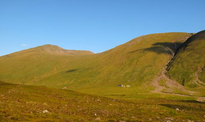
I left the house just before 2000 and an hour later I was setting off on the track that winds uphill below the great, gully-riven face of Sgurr nan Ceannaichean. The track climbs to a rocky knoll, avoiding the deep gorge of the Allt a'Chonais, before descending into the flat-floored upper glen known as the  Pollan Bhuidhe. After the effort of the ascent, still within earshot of the road and railway in Glencarron, the descent brings a liberating feeling of leaving the world behind, of dropping down into a silent netherworld. The name translates, as far as I can tell, as yellow poppy, which seems a strange choice or perhaps an incorrect translation. I love country like this, where the landforms themselves define the route, providing a natural and aesthetically satisfying path through the landscape. To my right the branching of alternative routes jogged memories of hill days past: the paths over Sgurr na Feartaig and up to the Bealach Bearnais, both of which provide fine routes into the great basin in which lie the Bendronaig and Bearnais bothies.

Camp spot on the summit
All is quiet in the Pollan Bhuidhe now, but in days gone by many travellers would have passed through,  following the old drove road from Poolewe to Fort Augustus. I followed in their footsteps as far as the peculiar trio of buildings at Glenuaig Lodge: the lodge itself; a sizeable turbine house; a small wooden bothy. The bothy is comparatively luxurious, boasting a bunkbed with mattress, electric light and - probably uniquely - electric heating courtesy of the adjacent hydro scheme. I could feel cabin fever building even in the 20 seconds or so that I spent inside and was glad to strike off up onto the slopes of Maoile Lunndaidh.

Loch Monar, early morning
I arrived on the pleasingly flat and grassy summit at half past eleven. The climb had been in daylight and I only just needed my headtorch to erect my tent. Once inside I became acutely conscious of the great mass of the mountain below me. It was a similar sensation to that felt when caving, or in the depths of a coal mine, but in reverse. When one is underground the awareness of such a mass of rock above is oppressive, alarming, claustrophobic. But when the rock is below, there is a liberating and intoxicating feeling of being pushed upwards into the sky and deep into the cosmos beyond. 
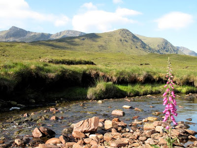
View across a mirror-flat Loch Monar to the north Mullardoch Ridge, Pait and the Gead Lochs
Glenuaig with Sgurr nan Ceannaichean and Moruisg behind
Bidean an Eoin Dearg, Sgurr a'Chaorachain and Sgurr Choinnich from near Glenuaig
The morning dawned fine and I was pacing around the plateau with my morning coffee shortly after 0600. It was a privilege to wake up not only amid such beauty, but in the heart of a landscape that is loaded with meaning, with stories and with significance through the writings of Iain R Thomson in 'Isolation Shepherd'. If only more corners of this great country had been brought to life through literature to the same extent as have these wild Monar hills.

It has been too long since I last visited this area. The previous occasion could not have been more different, an arduous winter journey to Maol Bhuidhe


Labels: , , , ,

Monday 4 July 2011

Some thoughts on land ownership

Recently added fence on the summit of Carn nan tri-Tighearnan, a very visible symbol of land ownership 
I can vividly remember the first time I became fully conscious of the concept of land ownership. It was 1998 and I was sitting in a cafe cum bookshop in Antigua Guatemala, relaxing with a litre bottle of Cervesa Gallo after a Spanish lesson. In my guidebook I read the following.

'The greatest challenge to a lasting peace stems from great inequalities in the basic social and economic structure of Guatemalan society. It's estimated that 70 % of the cultivable land is owned by less than 3 % of the population.'

This struck a chord with me because I grew up on the Isle of Bute, an island with a population of around 8000 which was owned by one man, Lord Bute. The comparable statistic was that 100 % of the cultivable land was owned by 0.01 % of the population! I realised that I had grown up under a feudal system and that this was a rather odd thing to have experienced in a developed countries in the last quarter of the 20th century.

View south over the River Findhorn from Carn an Uillt Bhric, a nearby trig as yet unmolested by fences 
It is a great shame that Scotland is divided up into sporting estates, vast parcels of land that are available to be bought and sold. As such the management of our wild land is subject to the whim of the landowner, land that is well managed today could easily pass into the hands of one who is motivated more by profit than by any sense of custodianship of wild land. Under this system of land ownership there is no obligation to preserve that which makes it special.

Recently I paid a visit to the summit of Carn nan tri-Tighearnan, the Hill of the Three Lairds. It is one of my local hills and takes its name because its summit marks the boundary of three estates.  The summit plateau is guarded by extensive peat hags and was previously imbued with a tremendous sense of open space.  I say previously because since I last visited a fence has been erected along the boundary line. If you start your ascent, as I did, from the River Findhorn, the fence must be surmounted in order to access the trig point. The fence is reinforced with chicken wire down to ground level. For the first time in millennia the mountain hair have been deprived of their right to traverse these high moors from the Findhorn to the Nairn. The fence now constrains them within their respective estates. When the winter snows drift against the fences will they be able, briefly, to roam at will.

It is not particularly straightforward to establish who owns estates or where their boundaries lie. The fence motivated me to find out the identity of this trio of fence-building lairds. I subscribed to the excellent whoownsscotland.co.uk and satisfied my curiosity. 

The three fence-building lairds are, clockwise from bottom left, the Moy Estate (owned by John Mackintosh of Mackintosh); Holme Rose Grouse Moor (Owned by M.M. Hasson (1/2), W.D. Armstrong (1/3) F.E. Ratky (1/6)); Cawdor Estate (owned by Cawdor Trusts, Colin RV Campbell, (7th Earl of Cawdor) & Isabella Campbell (Countess of Cawdor) and Angelika Campbell, Dowager Countess of Cawdor) 
I met a couple of elderly baggers on the summit. They were true, blinkered, list-ticking baggers in that they had climbed all the Munros before moving on to the Corbetts. Someone had then suggested that they should climb Suilven and Stac Pollaidh and that had started them ticking their way through the Grahams. They suggested that grants were probably available to the landowners subsidise the construction of fences such as the one we had recently scaled. Do any readers know if such fences are indeed subsidised from the public purse, and if so, to what extent and, most importantly, why?

Labels: , , ,

<data:blog.pageTitle/>

This Page

has moved to a new address:

http://livingmountain.net

Sorry for the inconvenienceā€¦

Redirection provided by Blogger to WordPress Migration Service