Friday, 20 April 2012

Bog wood: the Caledonian forest and climate change

Exposed bogwood on the shores of the channel between Loch Bad an Sgalaig and Dubh Loch, near Gairloch
Anyone who has wandered the Scottish hills must have at some point been perplexed by the presence of bog wood, preserved tree stumps with radiating roots that protrude from the peat in what appear nowadays to be the most unlikely of places to find a tree. They can most often be observed where flowing water has eroded banks of peat, revealing the bog wood, the wizened, bleached tentacles of giant fossilised star fish. Some of the best examples are to be found on the edges of dammed lochs, as in the photo above, where the rise and fall of the water level gradually washes away the peat, leaving the bog wood trunks clearly exposed and undamaged, poised, spider-like on the gravel, a memorial to the great Caledonian Forest.


I recently read Emma Wood's 'Peatbogs, Plague and Potatoes', an excellent book that traces the evolution of the landscape we see around us today and provides a particularly good account of the chronology of afforestation and deforestation since the end of the last ice age. She concludes that climate change rather than human activity was responsible for the decline of the great forests that once cloaked the Scottish landscape.


Over the years I have heard many theories regarding about how Scotland transformed from forest to bog: that the trees had been chopped down by farmers; eaten by over stocked sheep and deer; consumed by wood hungry industrial activity such as shipbuilding or iron smelting. Doubtless all of those causes have played a part at various points in history and in the present day, but when evidence from pollen samples preserved in loch sediments are considered alongside indicators of past climate such as Greenland ice cores, the evidence points to the main culprit being the worsening climate. The loss of tree cover from areas with little or no human intervention, such as Rannoch Moor, supports this version of events.


The age of the landscape that we see around us today is measured not, like the age of the underlying rocks, in millions or even billions of years, but in mere thousands.  The individual landforms that make up this landscape, the glacier sculpted hills, the mounds of meltwater transported rock and gravel, did not exist until the ice receded at the end of the last ice age around 11,000 years ago.

Though the landforms themselves have maintained broadly the same shape since the ice melted, they have appeared in various guises. For a couple of hundred years after the ice melted the landscape would have been of bare tundra, home to mammoths, woolly rhinoceros, elk, wild horses, reindeer, Arctic fox and lemmings. Once soil formed from the glacial till, around 11,000 years ago, trees began to colonise the land, obscuring the landforms. At first there were tundra plants: willow, juniper and rowan. Then followed birch and hazel. Finally, 8 - 9 thousand years ago came elm, oak and Scots pine. As the climate continued to warm, this mixed forest cover reached up the flanks of the mountains. Of the tundra animals only the elk adapted, but forest animals walked over the land bridge that connected Britain to continental Europe to colonise this newly formed habitat;  red and roe deer, a massive bovine called an auroch, wild boar, badgers, squirrels, otter, beaver, lynx, bear and wolves. In short, Scotland was at least as diverse an environment as the contemporary north American wilderness, literally teeming with animal life.

The animals shared the landscape with a small population of Mesolithic hunter gatherers and it is tempting for me at least, to think of this as a semi idyllic period in which there was nothing but satisfying outdoor activity, food would have been plentiful, though the risk of predation by large animals would have been very real.

Idyllic or not, this period of a small population living in harmony with the environment was relatively short lived. By five thousand years ago Scotland had moved into the Neolithic, most of the population were at least part time farmers and had started to exert their influence over the environment, clearing trees for fields. There were perhaps only a few thousand of them, so the cleared trees were able to regenerate, until the climate took
a turn for the worse. Conditions had been getting warmer, reaching an optimum around six thousand years ago. This warming was also melting the polar ice caps and around this time the sea levels rose sufficiently to make Britain was an island, and by five thousand years or so ago the conditions were warm and dry enough to be unfavourable to large stands of trees. Meanwhile agriculture was becoming more established and Neolithic monument building was nearing its peak.

Between 4 and 2.5 thousand years ago, perhaps abetted by the cooling sulphate particles from an eruption of Iceland's Hekla volcano, the climate deteriorated. Temperatures dropped and rainfall increased, possibly an increased maritime influence on the climate as sea levels rose,  making an island and reducing the size of the landmass. The rain leached nutrients from the soil, resulting in a loss of fertility. The treeline fell as heather moorland and blanket bog displaced the forests. In 'The Scots: A Genetic Journey' Moffat and Wilson go so far as to suggest, based on evidence from studies of population genetics, that the harsh environmental conditions following the Hekla eruption in 1159 BC may have resulted in a near complete, though temporary, depopulation of western Scotland.

The climate did warm in the 1st century, but by then the damage was done. Trees couldn't recolonise the moor and bog, so forest cover was restricted to favourable pockets. There were further cold snaps between the 6th and 8th centuries and again in the 9th, just before the start of the Medieval Warm Period. The Medieval Warm Period saw a return to upland cereal growing, with areas that had not been cultivated since the peak of the Neolithic falling under the blades of iron ploughs. This same warm period saw the Norse expansion into Iceland, Greenland and beyond into North America.

It was the Norse colonies that suffered first when the medieval warm period drew to a close in the late 13th century and by 1310 the Little Ice Age was really biting in Scotland. The climate was somewhat warmer in the first half of the 16th century, but harsh, Little Ice Age, conditions, continued to affect life in Scotland intermittently until 1900. As was the case in 1159 BC, cold spikes were compounded by the cooling effect of sulphate particles from volcanic eruptions - Iceland's Laki in 1783 and Indonesia's Tambora in 1815 - with disastrous consequences for the human population.

It is often the case that gaining a little knowledge merely serves to highlight vast swathes of previously unrecognised ignorance. Learning how a few thousand years of climate history have exerted such profound changes in my immediate environment has awakened in me a great desire to find out more about the preceding billions of years of climate and the diverse landscapes and environments of the past.

Assisting me on this journey will be two recent discoveries, 'The Goldilocks Planet' by Jan Zalasiewicz and Mark Williams, subtitled 'the four billion year story of Earth's climate' and the thoroughly excellent Bits of Science blog, a great source for summaries and interpretation of recently published climate science.  Knowledge of past climates and of the factors affecting them is evolving so rapidly that books inevitably struggle to keep pace. In my opinion such studies of past climate are the most important science of our time, for it is only through understanding the past that we may predict and prepare for the climates of the future.


Labels: , , , ,

Tuesday, 27 December 2011

Landscape and identity: Bruce Chatwin's 'The Songlines'

Wildflower meadows at the base of Uluru (Ayers Rock). The photos that accompany this post were taken when I traveled in Australia in 1998
My plan when I started this blog back in 2009 was to use it to as a platform on which to explore the connections that exist between landscape and identity. Such connections are abstract and intangible; consequently I have touched on the topic infrequently and obliquely. A recent work trip to the US provided me with the time and space to re-read a favourite book that has a lot to say on this subject, Bruce Chatwin's 'The Songlines'.


Published in 1987, the book describes Chatwin's travels among the Aboriginal peoples of the area surrounding Alice Springs in Australia's red centre. He gained access to these normally reticent people courtesy of Arkady, who was surveying the route of a proposed railway between Darwin and Alice Springs, working with the traditional owners to identify their sacred sites so that the railway could be built with as little adverse publicity as possible. 'The Songlines' paints a vivid picture of the country and its inhabitants. But it is more than a travelogue, along the way Chatwin lays out his ideas on nomadism and on the roots of human aggression. Almost twelve years had elapsed since I read  'The Songlines'  for the first time. The aspect of the book that stuck with me over that time was its description of the Aboriginals' deep and complex relationship with their land, which I will attempt to summarise below.

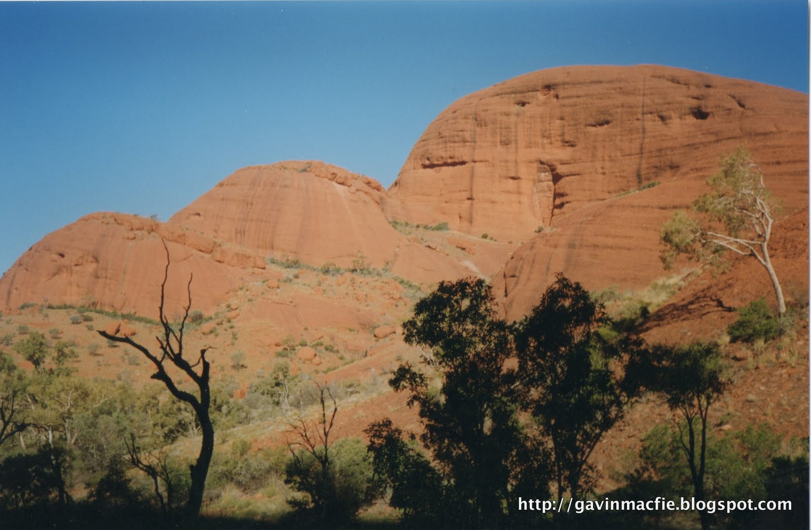
Kata Tyuta (the Olgas)
The song lines or dreaming tracks are known to the Aboriginals as the 'footprints of the ancestors', legendary totemic beings that wandered over the continent in the Dreamtime, singing out the name of everything that crossed their paths, singing the world into existence. The ancestors were generally animals; for example kangaroos, echidnas, budgerigars, ants or termites. The ancestors fashioned themselves from clay and traveled through the country scattering a trail of words and musical notes along the line of their footprints. The concept of going on walkabout - disappearing into the bush for weeks or months on end - was popularised by the film 'Crocodile Dundee', however I don't recall Paul Hogan mentioning that when an Aboriginal goes on walkabout he retraces the steps of his ancestor and sings the ancestor's songs, recreating the Creation. For the Aboriginals the land existed first as a concept in the mind, only once it had been sung did it really exist. 


Everyone inherited, as his or her own private property, a stretch of his or her ancestor's song and the country over which the song passed. A man's songs were the title deeds to his territory. One may lend or borrow song, but never sell or destroy them. Stops are handover points where the song passed from one's ownership, perhaps to a member of a neighbouring tribe in who shared one's dreamtime ancestor. Elders would advise travelling only 2 or 3 stops down the songline, but man may acquire ritual knowledge, thus extending his song-map and his territory. If a man strayed from his songline without first acquiring the necessary songs, he was trespassing and could expect rough treatment - even a spearing - from the owners. But if he had the song he could rely on their hospitality.


Most tribes speak the same language as their neighbours, or at least a similar one. However, song cycles may pass through many language barriers, for example following lines of reliable waterholes from Broome in the Northwest right through the centre to Adelaide in the South, passing through 20 languages en route.  For example in 1900 an Arnhemlander walked from his home, northeast of Darwin, to the south coast. There he found a wife, who he took home to the opposite side of the continent. Her brother accompanied them on the return journey and did the reverse.


The stone country of Kakadu National Park
The real mystery and beauty of the songlines is that an Aboriginal would be able to recognise the land being sung by a member of another tribe from a thousand miles away, despite not knowing a word of the language in which the song was sung. Chatwin reported that at least three theories had been proposed. Firstly there was telepathy. Secondly there was something that sounded like astral projection or the shamanic 'flying' described by Carlos Castaneda.  Lastly, the most likely explanation, which is that the land itself was encoded in the melody and rythm of the song. The melodic contour describes the lie of land directly, geographical features were rendered in particular note combinations. For example a listener would be able to count the number of river crossings or changes in gradient and pick out the precise position on a songline. The music of the dreamtime was thus a memory bank for finding one's way about the world. Chatwin tells of accompanying a group of Aboriginals in a Toyota Landcruiser, bumping along a dirt road. He noted that one of the men was singing very quickly, his lips a blur. The cadence of his song altered with the speed of the vehicle, suggesting that his song described the country in real time, at walking pace.


In Aboriginal belief an unsung land is a dead land: if the songs are forgotten the land itself will die. Periodically the elders of a totemic clan may decide that it was necessary to sing their song cycle from beginning to end. All owners would assemble at a 'Big Place' and sing their sections in order. A Big Place would be a significant landscape feature, such as those in the photographs that accompany this piece, Uluru, Kata Tyuta, Kakadu and Karlu Karlu. Many songlines would converge at a Big Place making them important for trade and for arranging marriage between members of different tribes.


The Aboriginals of Australia are unique in having maintained a stable and mature hunter gatherer society for tens of millenia, perhaps fifty thousand years. Hence their beliefs may provide the best window available into the minds of our own distant ancestors. There are other constructs that are remeniscent, to some, of the songlines: Britain's ley lines; the dragon lines of Feng Shui; Lappish singing stones; the Nazca lines of Peru. Yet Chatwin felt the songlines not be be a peculiarly Australian phenomenon, but to be universal; that they were the means by which man had marked out his territory and organised his social life. All other successive systems were variants - or perversions - of this original model.


The main songlines in Australia appear to enter the country from the north or northwest - from across the Timor Sea or the Torres Strait - and from there weave their way southwards across the continent. It is possible - perhaps probable - that they represent the routes of the first Australians as they traversed the country around sixty thousand years ago. Chatwin presented an enchanting vision of  songlines stretching across the continents and through the ages, speculating that wherever men have trodden they have left a trail of song, and that these trails must reach back in time and space to the region in Africa's Rift Valley from which all modern humans originated. 


Karlu Karlu (the Devil's Marbles)
We may  now and again catch an echo of these trails of song. Chatwin speculated that the whole of classical mythology might represent a totemic geography of the ancient world. I have not read his later work and so don't know if he was able to expand on these ideas prior to his death in 1989. It strikes me that these echos may even be audible in Scotland, that through legend and placenames it may be possible to reach back through time and to see into the minds of the first hunter gatherers that migrated into Scotland at the end of the ice age, eleven thousand or so years ago. 


This may seem far-fetched, but let me give you an example of an echo that I heard on my recent trip to the Isle of Jura to view the Corryvreckan whirlpool. Corryvreckan has been translated as ‘cauldron of the plaid’. The plaid in question was owned by the Goddess of Winter, Cailleach Bheur.  As winter approached the Cailleach could be heard washing her plaid in the swirling waters of the Corryvreckan for three days – possibly a reference to the enhancement of the whirlpool’s roar by the equinoctial gales. After such treatment the plaid was pure white and became the blanket of snow that covered the land. Placenames containing Cailleach are common in Scotland and are often translated as 'old woman' or 'witch'. But could it be that all these Cailleach landscape features are linked to ancient legend, and that a route connecting them might trace the path taken  by some form of dreamtime ancestor and by inference the migration routes of the first Scots?


I'm going to finish by restating the Aboriginal belief that an unsung land is a dead land: if the songs are forgotten the land itself will die. I visited that wild west coast of Jura twice in 2011 and both times I  publicised it online through word and picture (see the first visit here). Being actively involved in the popularisation of wild places makes me slightly uneasy, for part of the attraction of these places is that one can count on not meeting other people. But I believe it is also important to spread the message and keep the place alive, after all would I even have been there had W.H. Murray not inspired me by writing of his visit? For me that rugged coast will always be there, and it will always be important. But if no-one ever went there, if its beauty remained unseen - and it has been seen less and less over the centuries - at what point could it be said to no longer exist in any real sense? As I stood alone atop the flat-topped stump of Aros Castle behind the Glengarrisdale bothy, admiring the view out to sea and thinking these thoughts with the wind in my hair, I would like to think that in some small way I shared the feelings of deep reverence and connection with the landscape that an Aboriginal experiences as he sings his country into existence.


Glengarrisdale Bothy, Isle of Jura


Labels: , ,

Tuesday, 18 October 2011

Glen Roy: landscape interpretation through the ages


View up Glen Roy from the viewpoint. The famous Parallel Roads are discernible if you look hard enough.

The Scottish landscape as we know it  - the shape of the hills, the contours of the land, the courses of the rivers - has existed for around 10,000 years, since the ice melted at the end of the last ice age. The urge to interpret the landscape is a core part of the human condition, so we can be reasonably sure that there has been landscape interpretation for as long there have been people on the land. 

Inevitably such interpretations will have been  made within the context of the prevailing belief systems of the time. It is only very recently that they have been based on science, that we have been able to say with some degree of certainty how our surroundings came to have their current shape. It is ironic that as our understanding has advanced over the last 150 years or so the world's increasingly urbanised population has become disengaged from the landscape, disinterested in the answers that science can now provide.

This may have something to do with the complexity of those answers and with the impenetrable jargon in which geomorphology, the science of landscape interpretation, is cloaked. For example when a geomorphologist wishes to convey that an object is curved he describes it as 'arcuate'; on a recent excursion to the nearby Flemington Eskers my field guide perplexed me by describing the complex of low, braided ridges as 'anastomosing'.  It was during this outing that I began to wonder what the hunter-gatherers of the mesolithic thought about these striking landforms, how they incorporated them into their creation myths. 

I carried these thoughts with me last weekend to one of the few road-accessible parts of the highlands that I hadn't previously visited, Glen Roy. Glen Roy is famous for its Parallel Roads, distinctive lines that contour round the hillside at heights of 260, 325 and 350 m. They are prominent in the foreground of the image below, taken from the summit of nearby Creag Meagaidh.


The Parallel Roads are a particularly interesting example,  for a record exists of how they have been interpreted through the ages. In reverse order, stretching back into the mists of time, we have:

The scientific interpretation
In 1840 visiting geologist Louis Agassiz realised that they were were ancient loch shores, formed when the entrance to Glen Roy was dammed by the great valley glaciers of the final stage of the glaciation of Scotland, the Loch Lomond Readvance. During his tour of Scotland Agassiz, who had spent his time prior to that studying glaciers in the Alps, amassed an impressive body of evidence in support of Scotland's landscape having been sculpted by ice. These were new and controversial ideas and marked the start of the modern science of landscape interpretation. 

The position of the shorelines was defined by the height of cols or bealachs over which the trapped water could drain from the ice-bound lakes. As the ice advanced each bealach in turn was blocked, causing the water level to rise until it found another escape route. The first, 260 m road, was the shore of a large loch that extended out into Glen Spean, formed when the westward flow of water was blocked by the Spean Glacier, forcing it to drain eastwards over a bealach near Kinloch Laggan. When the Spean Glacier advanced further, sealing the entrance of Glen Roy, the water level in Glen Roy rose until it reached a col at 325 m, draining into the now isolated 260 m loch in Glen Spean near the Laggan Dam. In due course the advancing glacier reached this bealach too, forcing the loch to extend eastwards up Glen Roy until it reached the 350 m bealach at its head and escaped down the course of the River Spey.

The pseudo-scientific, biblically inspired interpretation
Prior to Agassiz the shorelines had been taken as evidence of elevated sea levels during the biblical flood. Even Charles Darwin, who contributed so much to other areas of science, lent his support to this version of events. 

The Celtic interpretation
The Celtic interpretation is one of pure legend, that the roads were created by the warrior Fingal to aid him in his hunting. Fingal, or Fionn mac Cumhaill, was a giant who is also reputed to have built the Giant's Causeway so there is an inconsistency of scale, it is not clear to me what use these human scale roads would be to a giant. 

The explanation above should make more sense when viewed in conjunction with this interpretive sign.
Beyond the Celtic interpretation
Celtic culture has only been present in Scotland for a tiny fraction the period over which it has been occupied. The millennia of indigenous (Pictish?) landscape interpretation that preceded it would be the most interesting to get into, yet we can only speculate as to what our distant ancestors may have believed. It is tempting to imagine that their views on landscape may have been similar to the Australian Aboriginal Dreamtime tradition of landscape interpretation, a tradition that is still very much alive today and laid out for the visitor in the form of interpretative signs. One example that sticks in my mind are the  Devil's Marbles, believed to be the eggs of the rainbow serpent. I once visited a cave in the Kakadu National Park in Australia's Northern Territory in which excavations had revealed evidence of continuous habitation for 40,000 years. The food remains in the archeological record had changed from marine to land-based origin as the sea level had risen and fallen over the years, but it is possible that the culture and beliefs of the people had remained relatively constant,  that the reverence for their land and its mythology-laden landforms felt by modern Aboriginals can trace its roots back through the oral tradition to that of the first Australians, tens of millennia previously. It would be wonderful to gain a similar perspective on Scotland's landscape, to be able to see it through the eyes of the first humans who colonised it at the end of the Ice Age. But this is nothing more than a delicious fantasy, for such knowledge is most certainly lost. Thankfully we have the modern science of geomorphology to fill the void.


Labels: , , , , ,

<data:blog.pageTitle/>

This Page

has moved to a new address:

http://livingmountain.net

Sorry for the inconvenience…

Redirection provided by Blogger to WordPress Migration Service